Doomscrolling dominates our feeds. Here are 50 reasons to believe we are tipping the balance back.
For International Day of Climate Action (October 24)
Open your phone on any given morning and the algorithm will serve you two competing flavours of dread.
In one tab, it is climate fatalism: record-shattering ocean heat, megafires, and "once-in-a-century" floods arriving every other Tuesday. In the next tab, it is AI anxiety: breathless warnings that artificial intelligence is nothing more than an energy-guzzling hallucination machine. Put those two narratives together and it is easy to conclude we are speeding toward the cliff with our foot on the accelerator.
For a generation, two words have haunted this conversation: Tipping Point.
In climate science, a tipping point is where incremental warming triggers a runaway cascade—where permafrost thaws, Amazon dieback begins, and Earth starts generating its own heat. To visualize how close we are, strategic risk briefings use the Planetary Habitability Index (\varphi Index)—an oncological analogy that maps biospheric decline across four clinical stages:
Stage I — Localised Malignancy (Asymptomatic Accumulation & Actuarial Denial): Oceans and forests silently absorb impacts while false negatives hide in our models and the economy treats climate as a manageable externality.
Stage II — Lymphatic Breach (Buffer Saturation & Systemic Inflammation): “YOU ARE HERE.” Carbon sinks hit capacity, weather patterns shift, the "uninsurability" era begins, and chronic supply-chain and food inflation take hold.
Stage III — Systemic Metastasis (Angiogenesis & Multiple Organ Failure): Irreversible tipping points flip, triggering self-heating, multi-breadbasket famine, sovereign debt collapse, and overwhelmed institutions.
Stage IV — Terminal Cascade (Hothouse Lock-In & Civilisational Necrosis): Ocean acidification destroys the marine food web, globalized supply chains and centralized grids fail, and humanity is forced into localized survival.
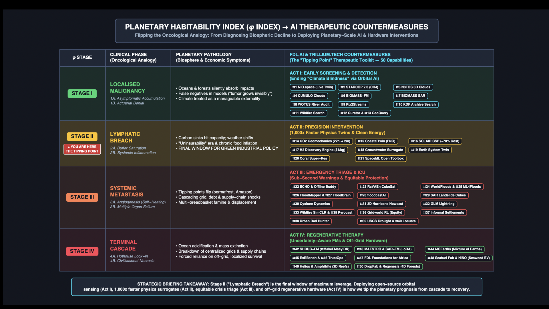
Stage II carries an urgent clinical prognosis: we are standing inside the absolute final window for radical green industrial policy and planetary intervention.
That is where the second kind of tipping point begins.
In physics and complex systems, a tipping point isn't only where things fall apart. It is also the exact moment where a counter-capability reaches critical mass—where intelligent, targeted interventions tip an entire system toward diagnosis, resilience, and regeneration.
Over the past decade, an international coalition of AI researchers, climate physicists, and space engineers at the Frontier Development Lab (FDL.ai), Earth Systems Lab (ESLAB.ai), and Trillium Technologies (Trillium.tech)—working shoulder-to-shoulder with NASA, the European Space Agency (ESA), the U.S. Department of Energy (DOE), USGS, Oxford University, Google Cloud, and NVIDIA—has been quietly building the clinical countermeasures for every single stage of the \varphi Index.
We are witnessing the moment Earth grows a planetary nervous system: satellites that think in orbit, supercomputer physics shrunk onto a tablet, foundation models humble enough to say "I don't know", and solar-powered machines that print coral reefs and plant forests from the sky.
Here are 50 concrete breakthroughs—mapped directly against the four stages of planetary risk—proving that the most important tipping point of our lifetime isn't the one we fear. It's the one we are building.
Act I: Countering Stage I (Localised Malignancy) Early Screening & Ending "Climate Blindness"
In Stage I of the \varphi Index, the "tumor grows invisibly" because oceans and forests mask the damage and false negatives plague our models. These 13 capabilities act as planetary-scale oncology screening—spotting invisible emissions from orbit, auditing carbon sinks, and unlocking petabytes of hidden data.
NIO.space (Networked Intelligence in Orbit): Achieved a triple orbital world-first on space-rated hardware—including the first in-orbit flood segmentation, the first on-board retraining of an Earth Observation model in space, and an operational methane pipeline (MARS-S2L) that has issued 2,776 alerts across 25 countries, permanently shutting down an Algerian leak that had spewed 27,000 tonnes of methane per year for a decade.
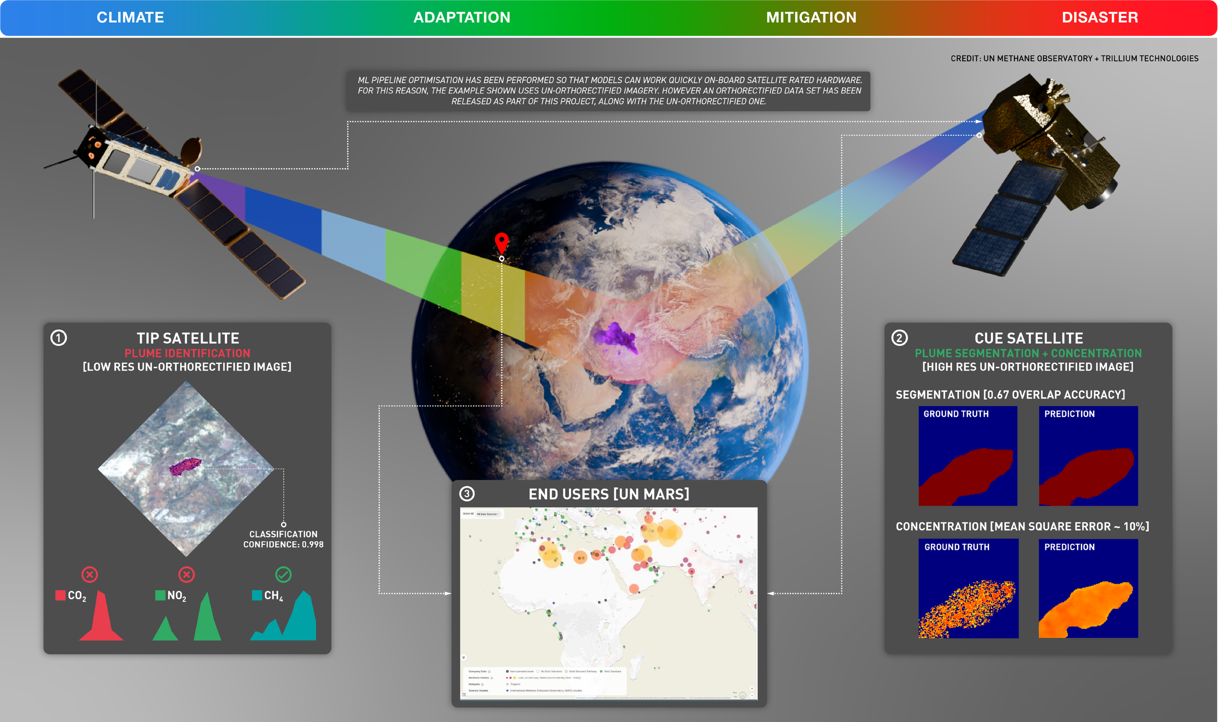
STARCOP 2.0 (On-Board Methane Tip-and-Cue): Spots invisible methane (\text{CH}_4) plumes directly on un-orthorectified raw satellite imagery with 99.8% classification confidence (\text{0.998}), improving state-of-the-art F1 detection scores by 27%, cutting inference time by 85% (30 seconds on satellite proxy hardware), and estimating gas concentration within ~10% Mean Square Error for the UN Methane Alert and Response System (UN MARS).
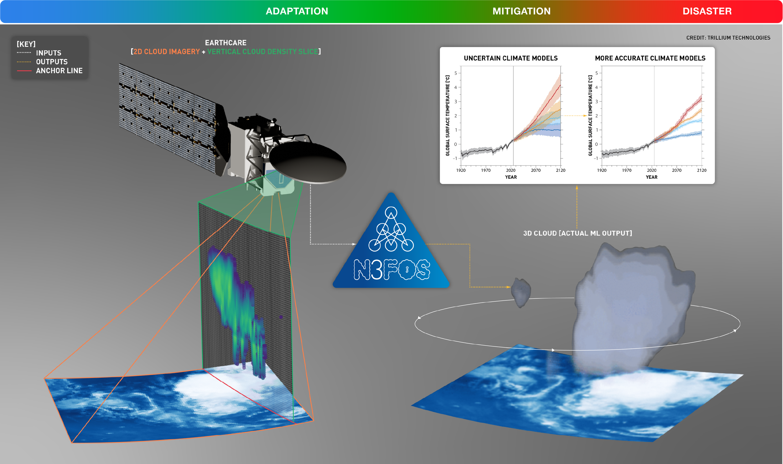
N3FOS (3D Cloud Reconstruction): Reconstructs volumetric 3D clouds at kilometer scale from a single 2D satellite image + a narrow vertical radar density slice (EarthCARE), stripping false negatives and narrowing the temperature uncertainty spread across 100-year global climate projections (1920–2120).
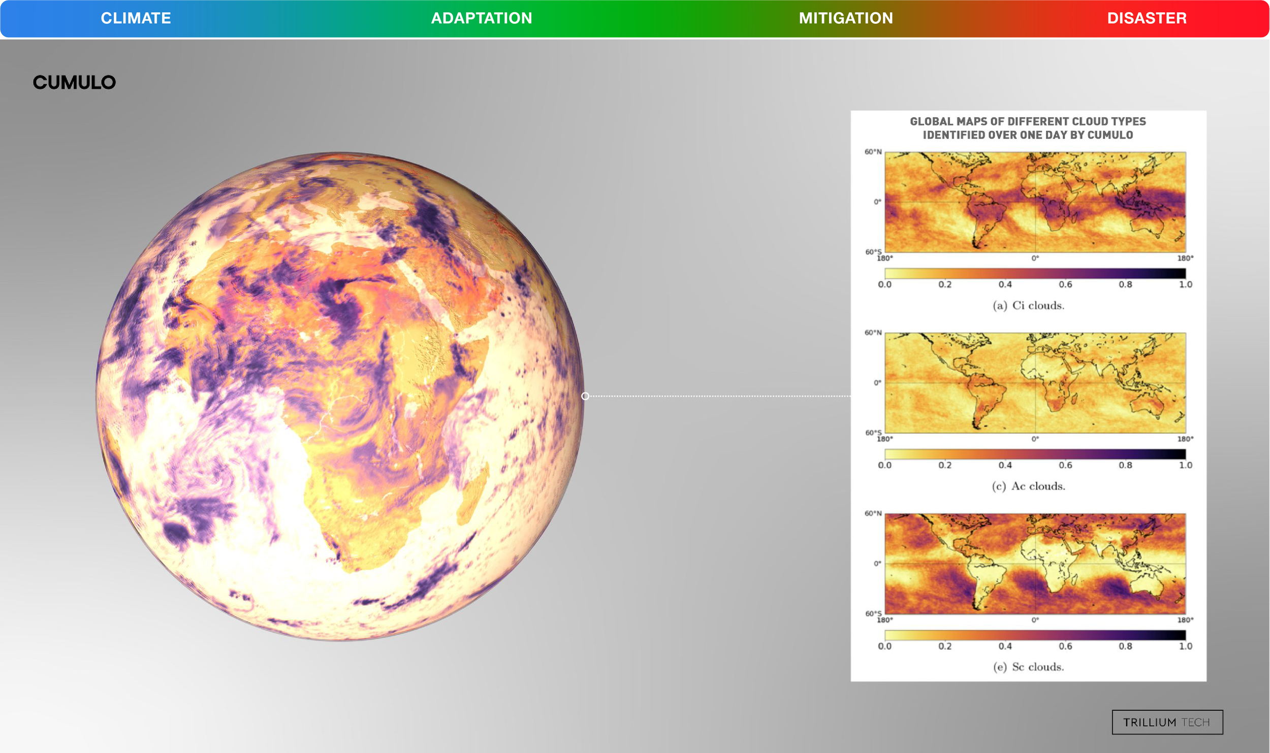
CUMULO (Global Cloud Classification): Winner of the Best Paper Award at the NeurIPS Tackling Climate Change with Machine Learning workshop, CUMULO was the first AI to classify cloud varieties globally at pixel level—solving one of the biggest blind spots in climate sensitivity.
Aerosol-Cloud Interactions (FDL Europe): Used machine learning to untangle how industrial aerosols seed and brighten marine clouds, quantifying human pollution's hidden "cooling mask" on global warming.
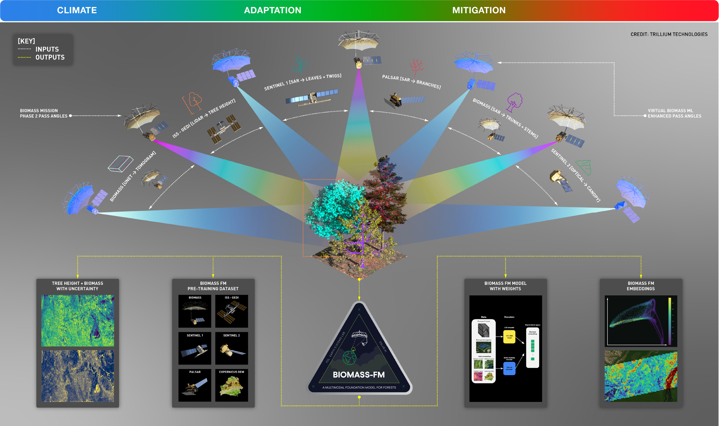
BIOMASS-FM (Multimodal Forest Foundation Model): Fuses 6 distinct spaceborne sensors across radar, LiDAR, optical, and elevation modalities (BIOMASS P-band, ISS-GEDI, Sentinel-1 C-band, PALSAR L-band, Sentinel-2, and Copernicus DEM) plus virtual ML-enhanced pass angles to weigh global forest carbon from leaves and twigs down to trunks and stems.
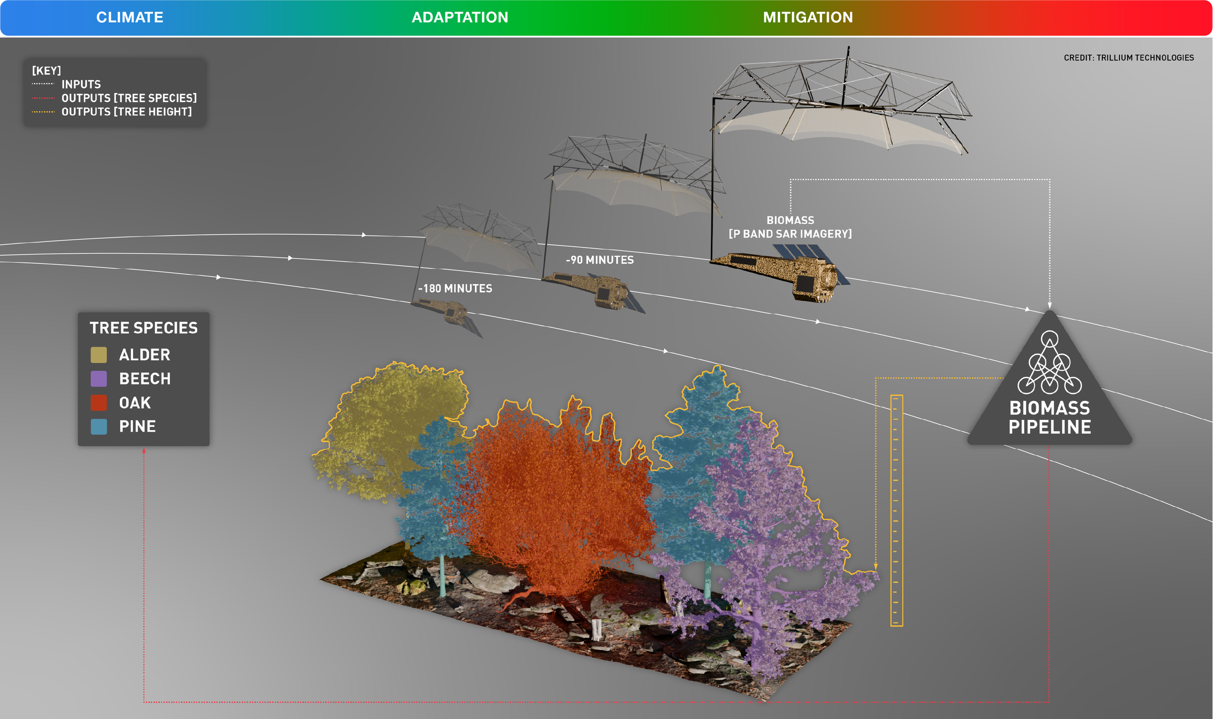
BIOMASS Pipeline (P-Band SAR Forest Characterization): Uses just 3 sequential orbital passes (-180 min, -90 min, and 0 min) of long-wavelength P-band radar to penetrate dense forest canopies, simultaneously measuring vertical tree height and classifying 4 distinct tree species (Alder, Beech, Oak, Pine) from space.
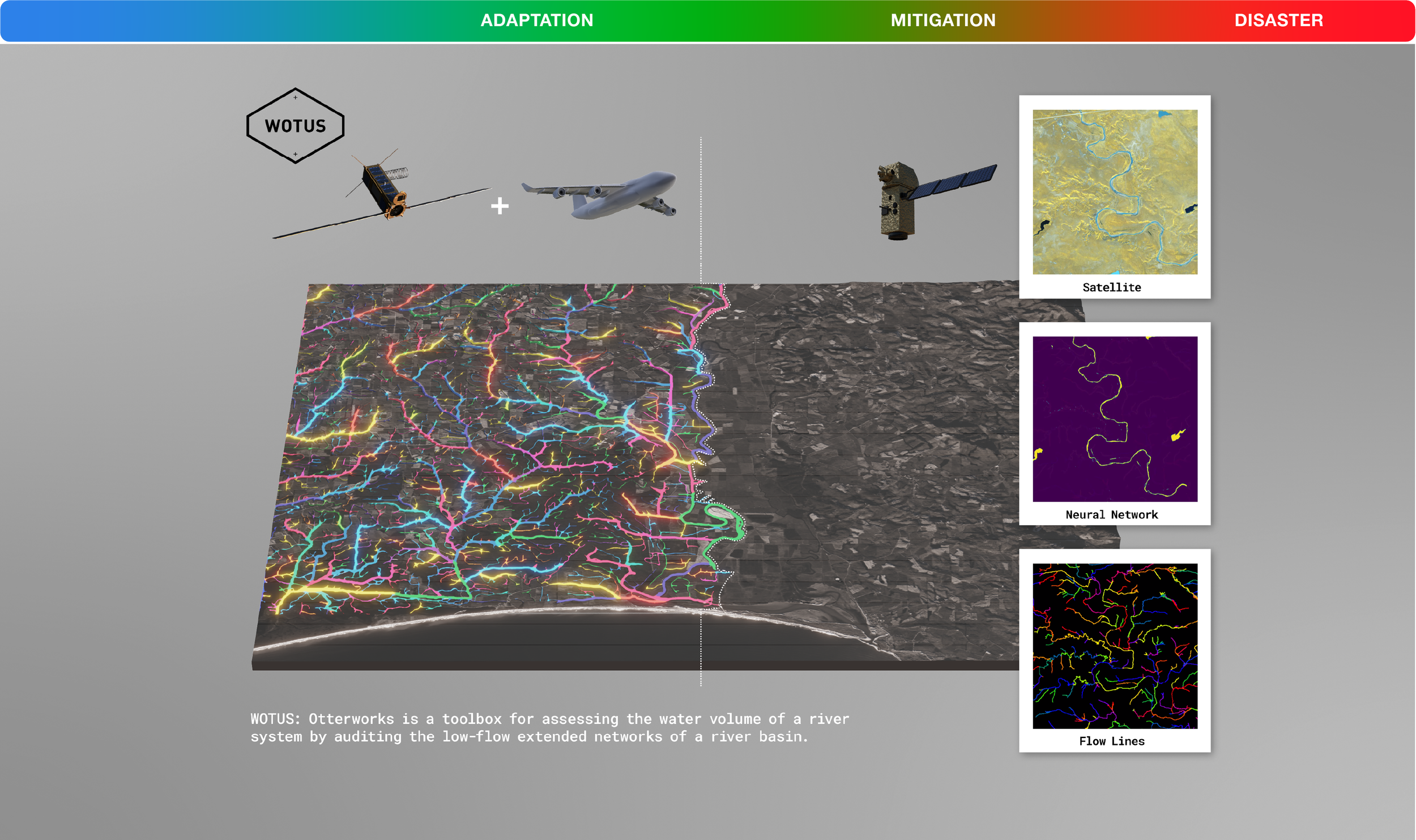
WOTUS / Otterworks (River Basin Auditing): Fuses multi-modal satellite imagery with airborne LiDAR via neural networks to map hidden, low-flow extended tributary networks across an entire river basin—auditing total water volumes that standard optical satellites miss.
Pix2Streams (Daily Ephemeral Hydrology): Combines 3-meter daily PlanetScope satellite imagery with 1-meter LiDAR data to detect narrow streams under 5 to 7 meters wide, outperforming baseline hydrology models by 30–40% to spot where droughts begin at the receding tips of watersheds.
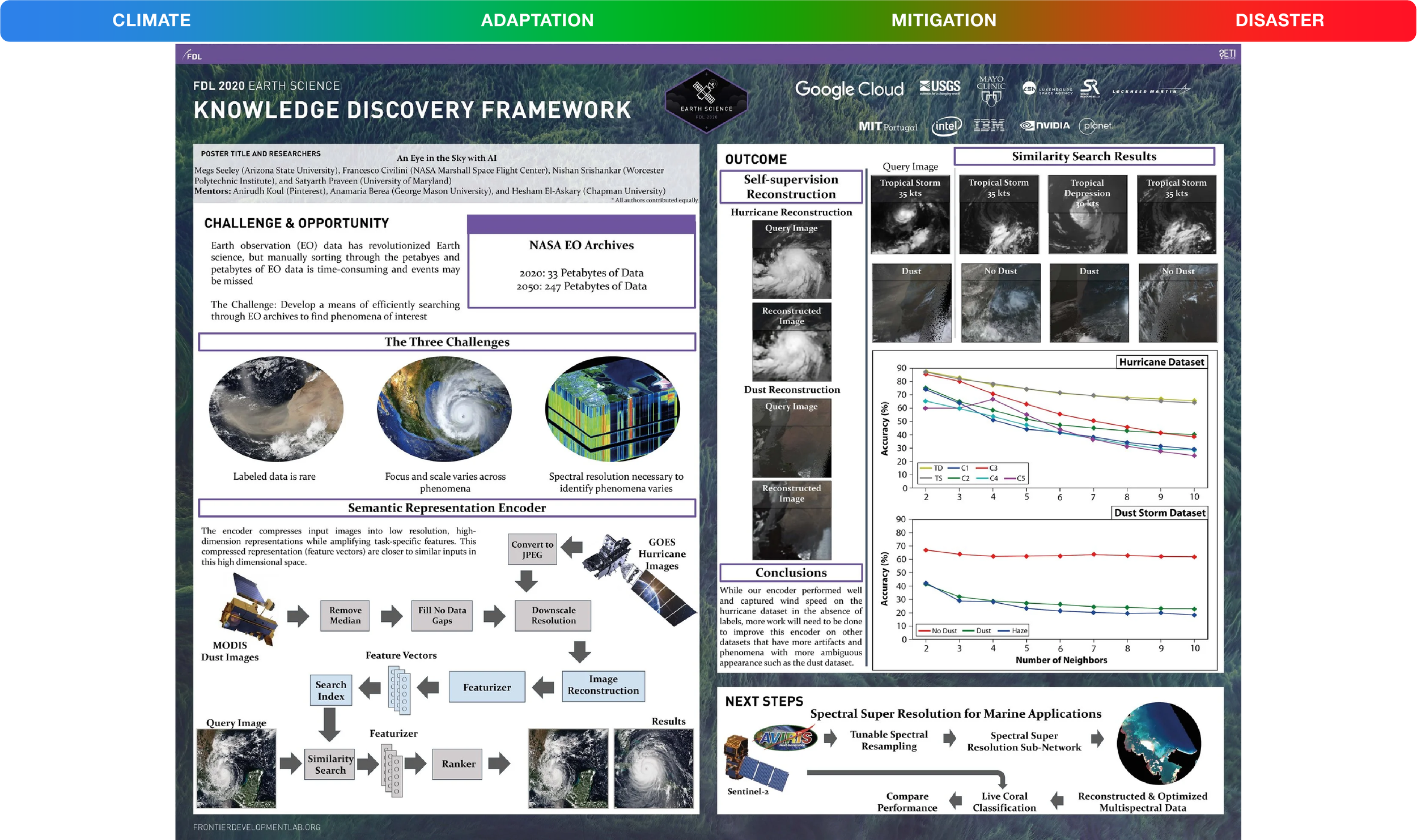
Knowledge Discovery Framework (KDF): A self-supervised semantic search engine that indexes unlabelled satellite imagery to help NASA navigate an Earth Observation archive projected to grow 7.5x—from 33 Petabytes in 2020 to 247 Petabytes by 2050—without manual human labeling.
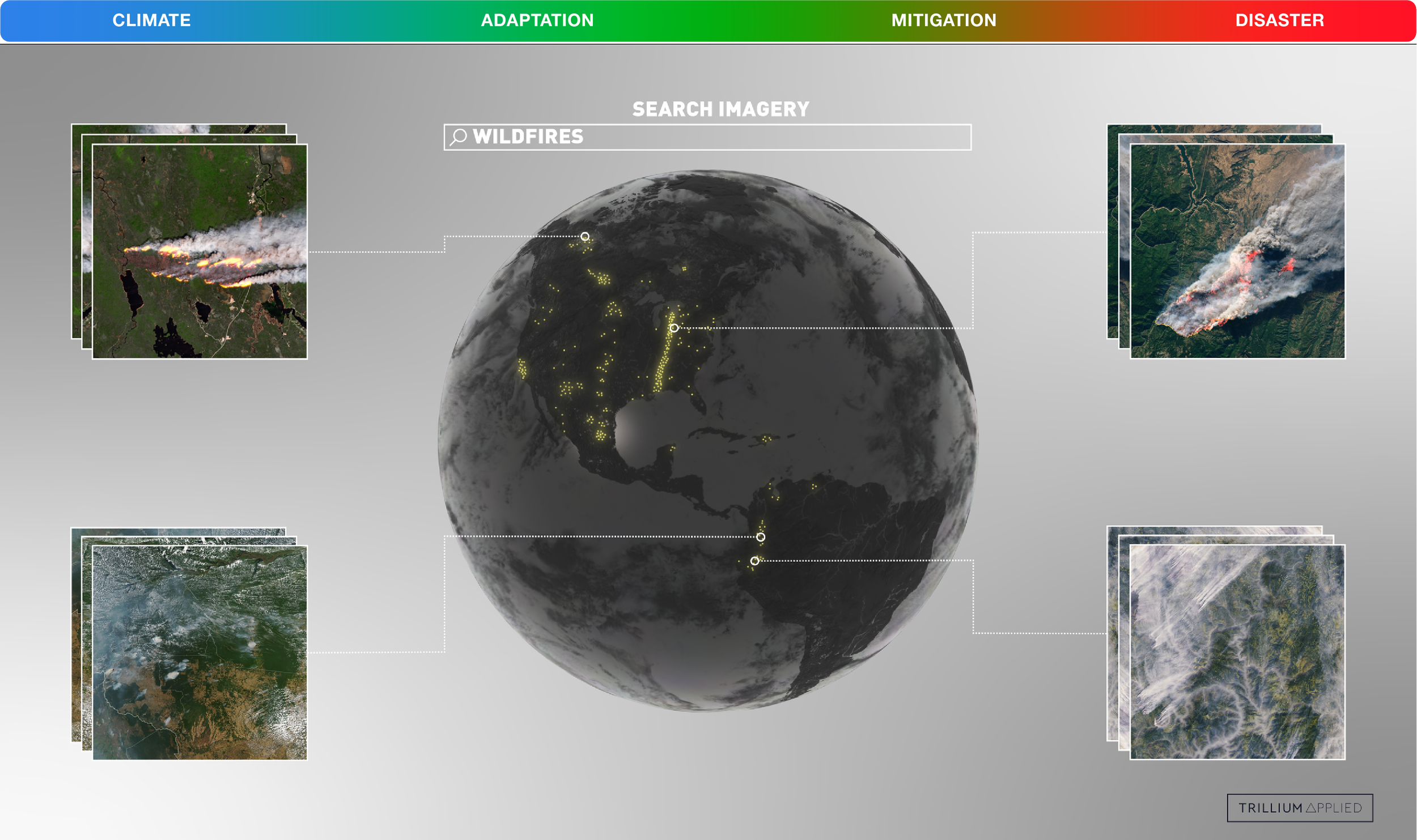
Global Imagery Similarity Search (Trillium Applied): Lets analysts type a single semantic query (WILDFIRES) to automatically cluster and retrieve matching active smoke plumes and burn scars across entire continents.
Curator (NASA Worldview Self-Supervised Search): Built the first self-supervised image embeddings capable of searching across disparate NASA archives—from Earth-observing satellites to Hubble and Voyager—without requiring pre-labeled training sets.
GeoQuery (Natural Language Earth Querying): One of the first agentic, queryable Earth observation tools, allowing scientists and policymakers to interrogate petabytes of satellite climate data using plain natural language.
Act II: Countering Stage II (Lymphatic Breach - "You Are Here") Precision Intervention & Clean Industrial Policy
Stage II is where carbon sinks saturate, systemic inflammation hits the economy, and we face our final window for radical green industrial policy. Historically, engineering clean energy and modeling carbon storage required a PhD, a supercomputer, and 22 hours of runtime. These 8 breakthroughs shrink supercomputer physics by 1,000x and accelerate the clean-tech transition.
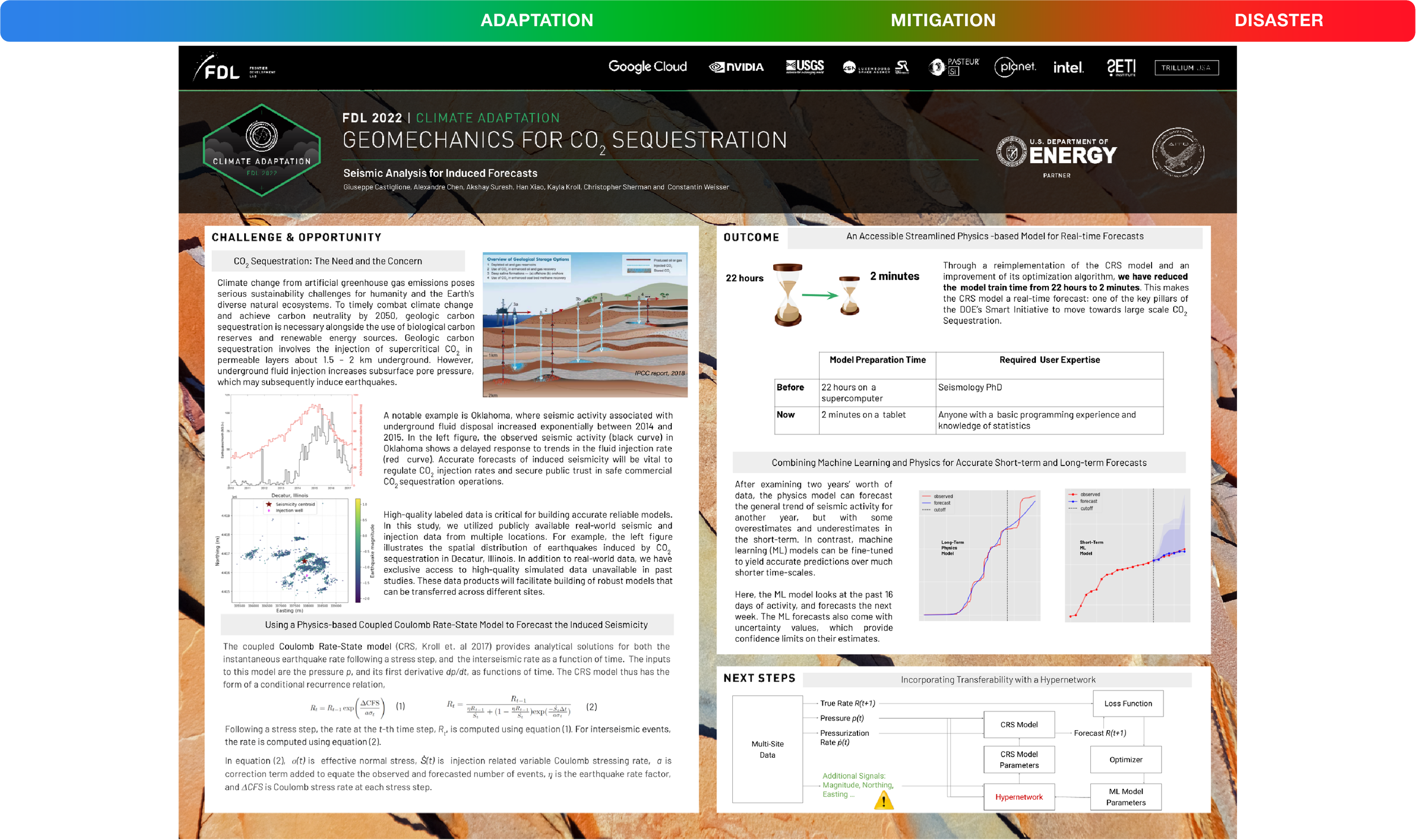
Geomechanics for \text{CO}_2 Sequestration: Slashed the time required to model and forecast induced earthquake risks from underground supercritical carbon storage (1.5\text{--}2\text{ km} deep) by 660x—from 22 hours on a supercomputer (requiring a Seismology PhD) to 2 minutes on a tablet (usable by anyone with basic programming and statistics skills).
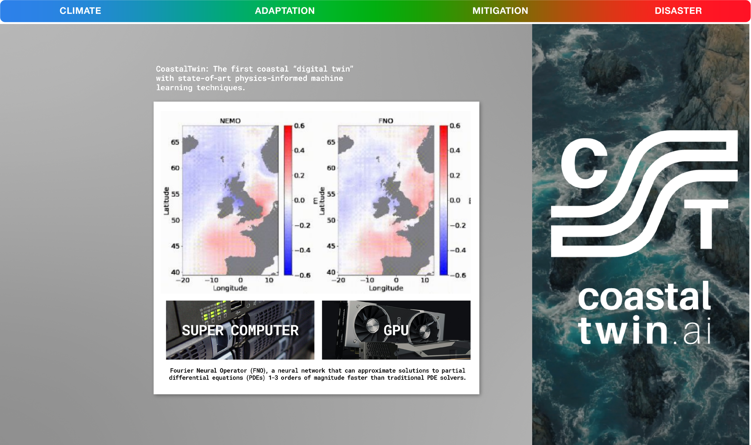
CoastalTwin (coastaltwin.ai): Created the world's first coastal digital twin using Fourier Neural Operators (FNOs) on GPUs, solving complex ocean partial differential equations 10x to 1,000x (1 to 3 orders of magnitude) faster than traditional supercomputer solvers like NEMO.
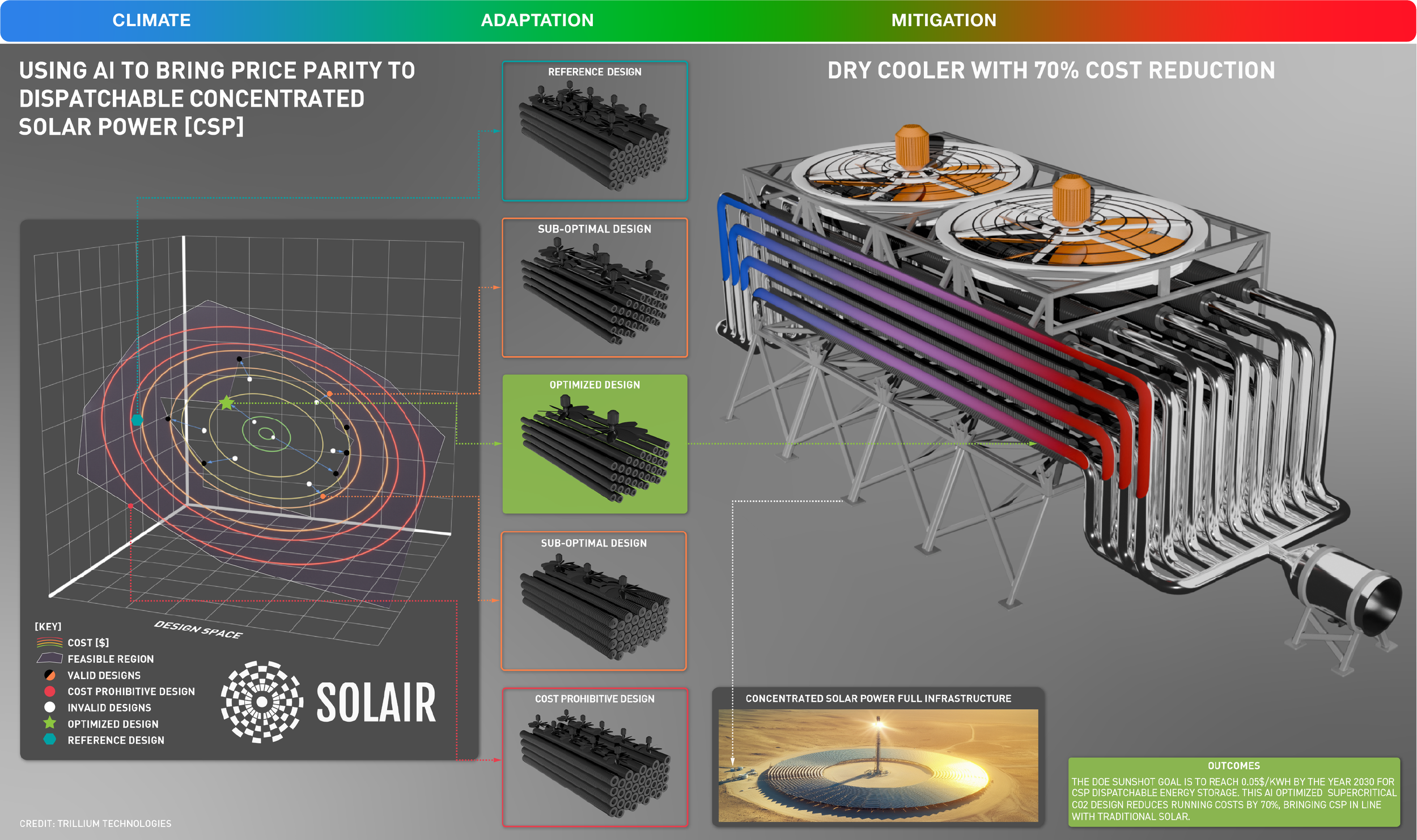
SOLAIR (AI-Optimized Concentrated Solar Power): Explored multi-dimensional thermodynamic design spaces to generatively engineer a supercritical \text{CO}_2 dry cooler that cuts running costs by 70%, helping dispatchable 24/7 Concentrated Solar Power reach the DOE SunShot target of \$0.05/\text{kWh} by 2030.
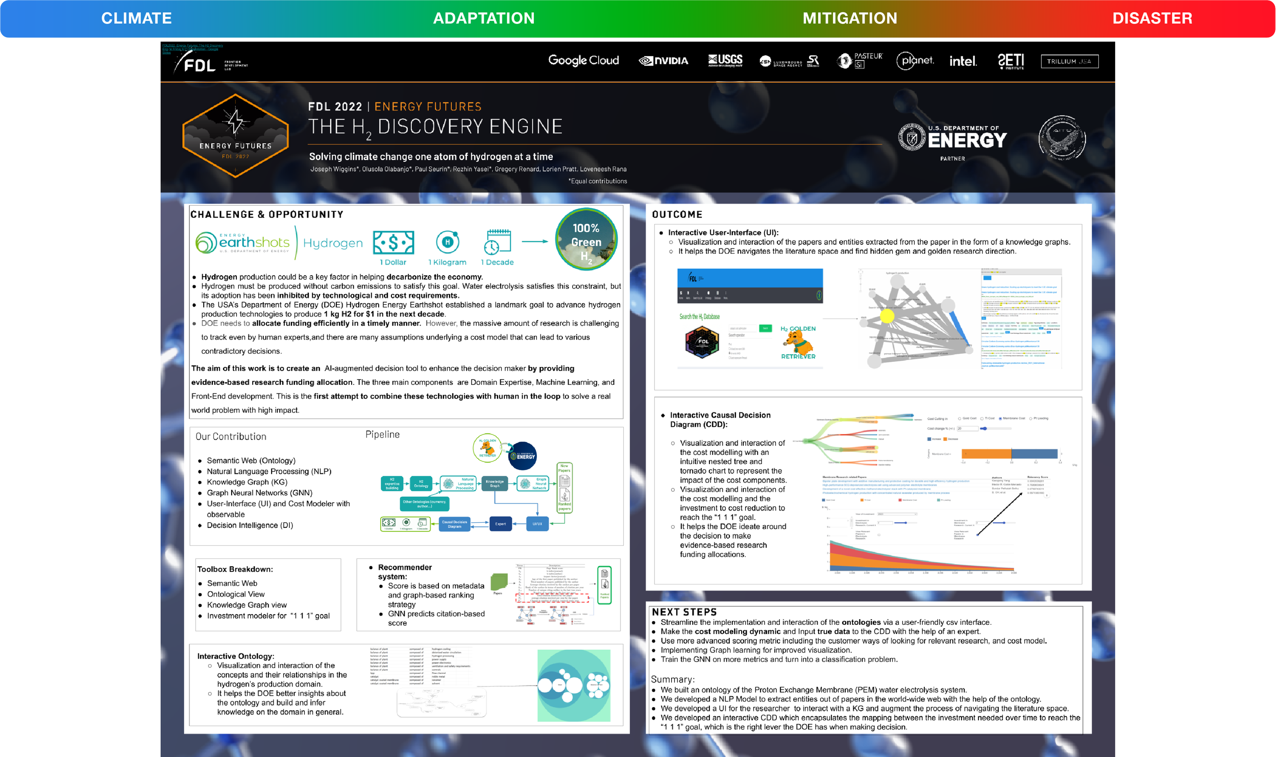
The \text{H}_2 Discovery Engine (H2 Golden Retriever): Combines a Proton Exchange Membrane (PEM) water electrolysis ontology, Knowledge Graphs, Graph Neural Networks, and an interactive Causal Decision Diagram to map scientific literature onto the DOE's "1-1-1" Hydrogen Shot goal: 1 kilogram of 100% green hydrogen for $1 in 1 decade.
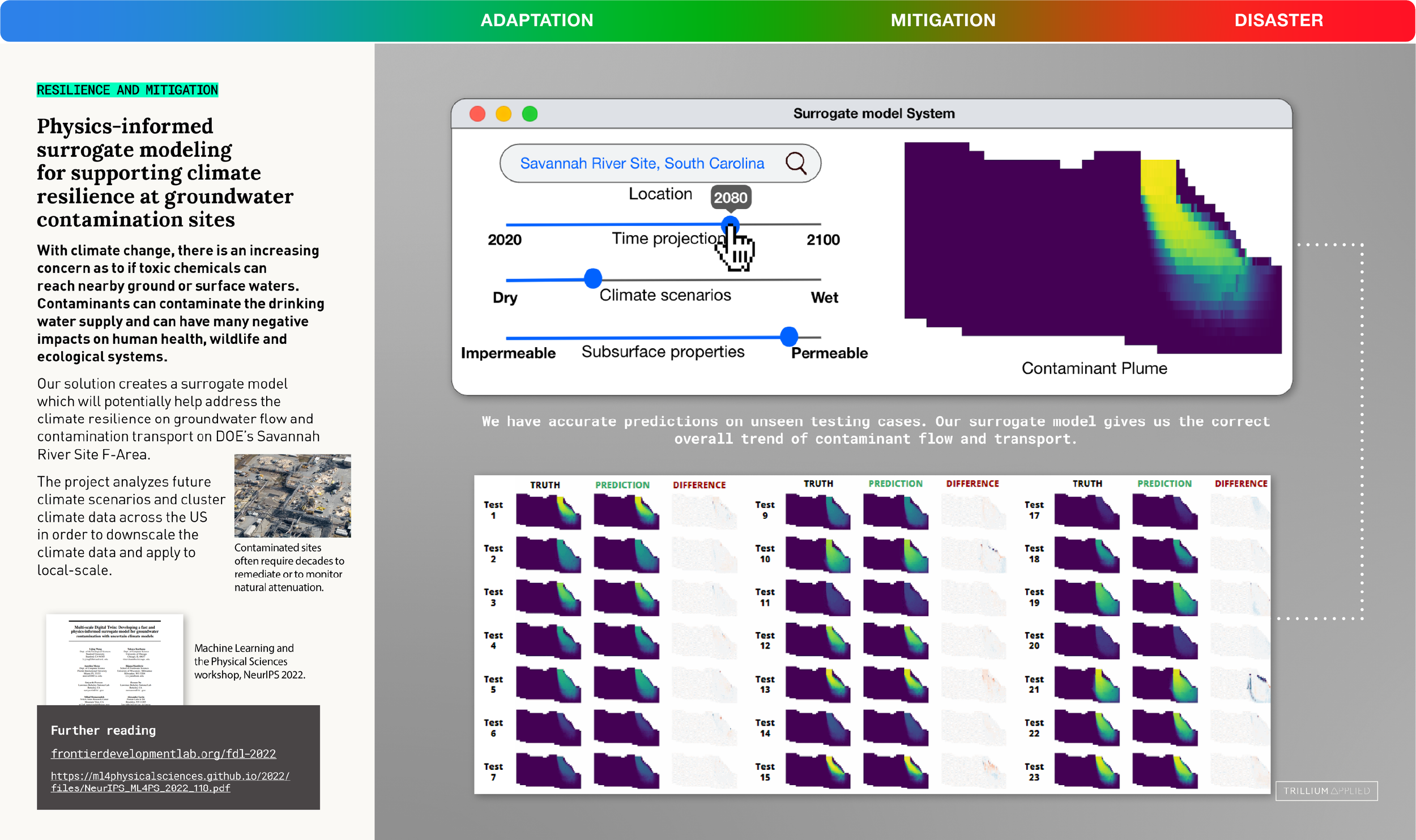
Groundwater Contamination Surrogate Model: Simulates 80 years of future subsurface toxic plume migration (2020–2100) in real time at the DOE Savannah River Site, letting planners interactively slide between dry/wet climate extremes and soil permeability in milliseconds instead of waiting weeks for physics simulations.
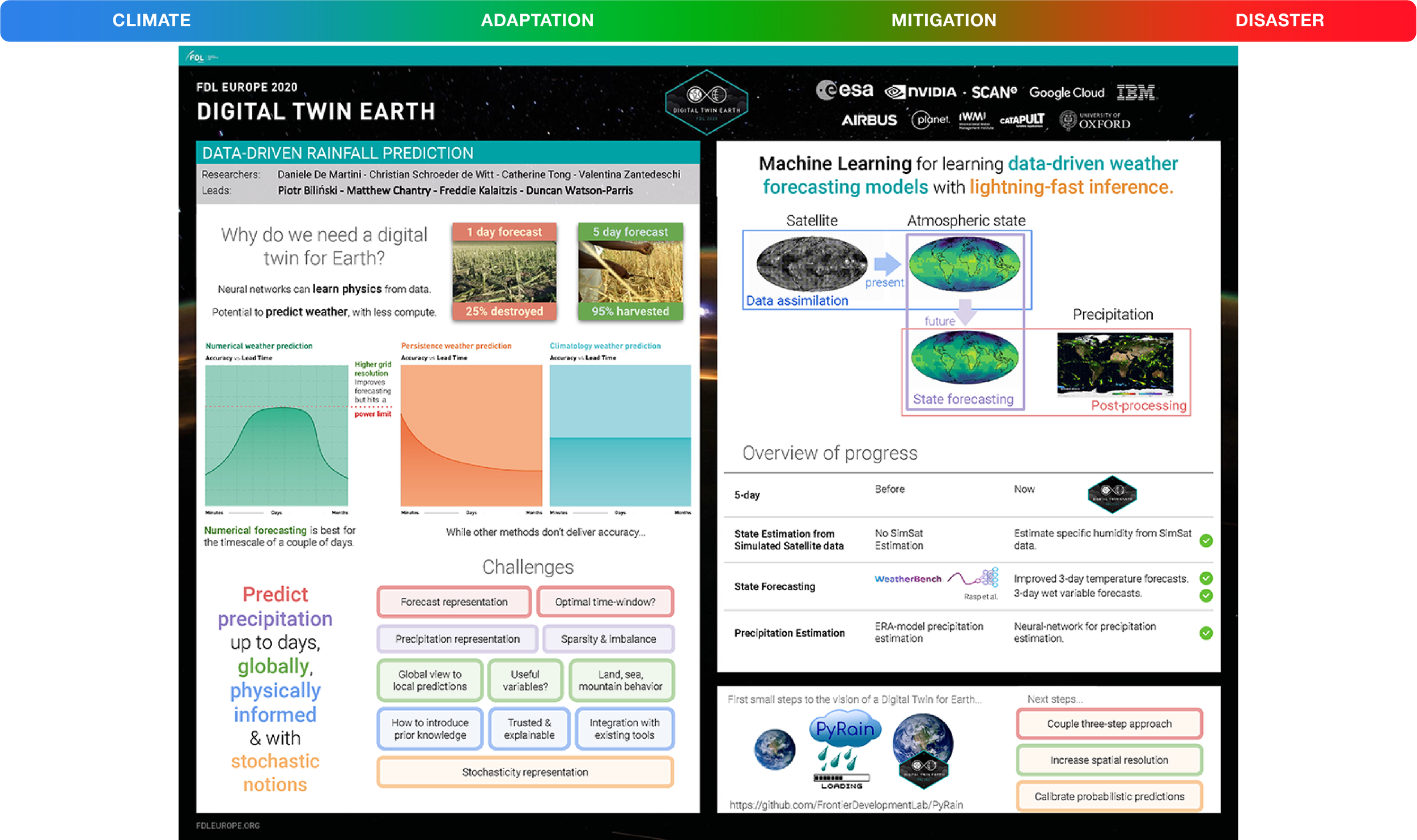
Earth System Digital Twin (EIE / ESDT): Developed neural-network emulators for Earth system sub-models that accelerate atmospheric radiative transfer and land-surface physics without breaking thermodynamic conservation laws.
Spectral Super-Resolution for Coral Reefs: Uses tunable spectral resampling between NASA's airborne AVIRISsensor and ESA's Sentinel-2 to reconstruct high-resolution multispectral data over oceans—enabling live coral reef health classification from free satellite passes.
SpaceML (Open-Source Reproducible AI): Named one of 2021’s Top Innovators, SpaceML is FDL and Trillium’s open-source MLOps repository that packages academic space-and-climate code into reproducible, one-click pipelines for global researchers.
Act III: Countering Stage III (Systemic Metastasis) Intensive Care, Triage & Equitable Life Support
Stage III warns of cascading infrastructure failures, extreme weather shocks, and food insecurity. With US weather outages already up 5x and 70% of transmission lines in the second half of their 50-year lifespan, these 20 systems act as planetary Intensive Care—compressing disaster response from hours to seconds and explicitly protecting vulnerable communities first.
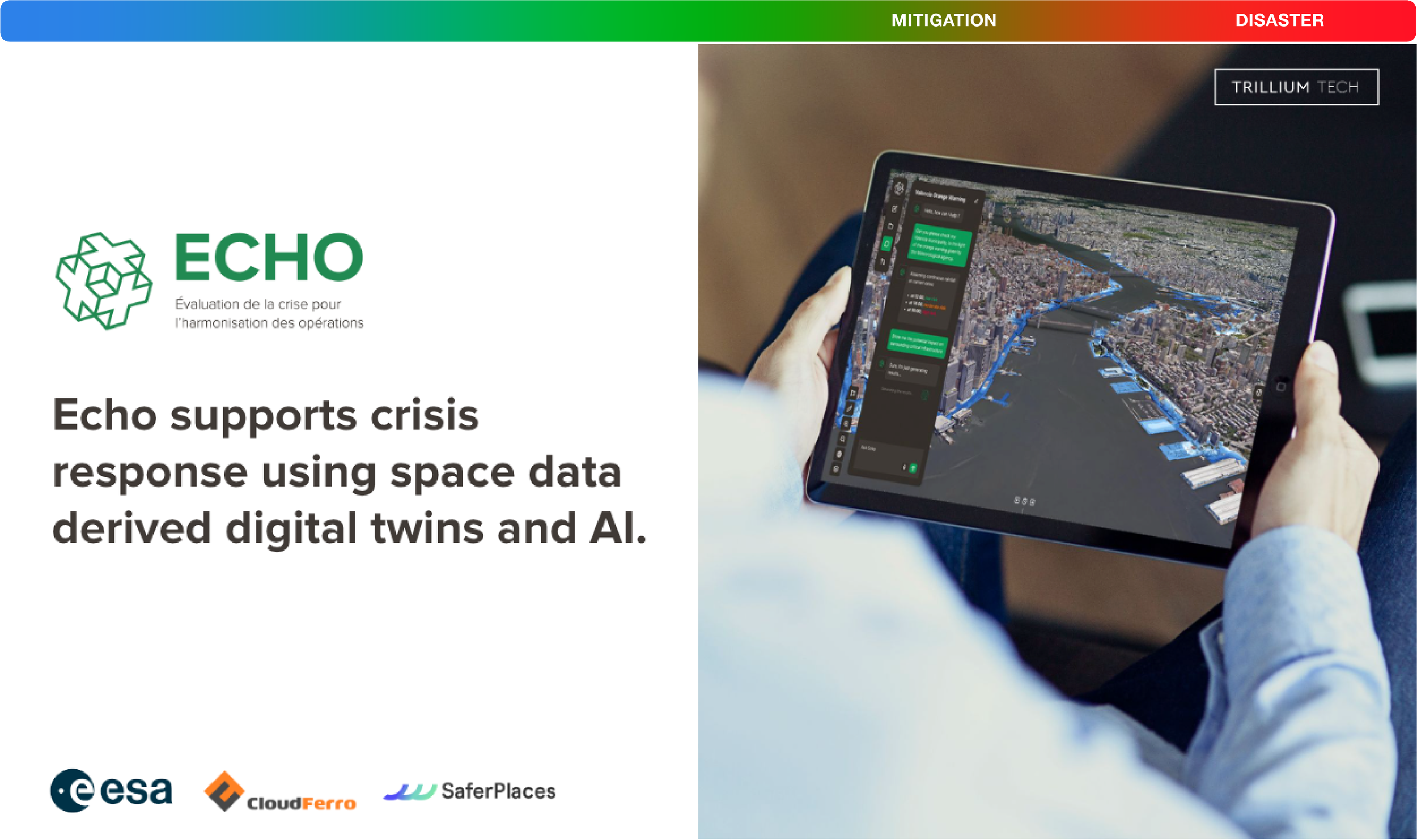
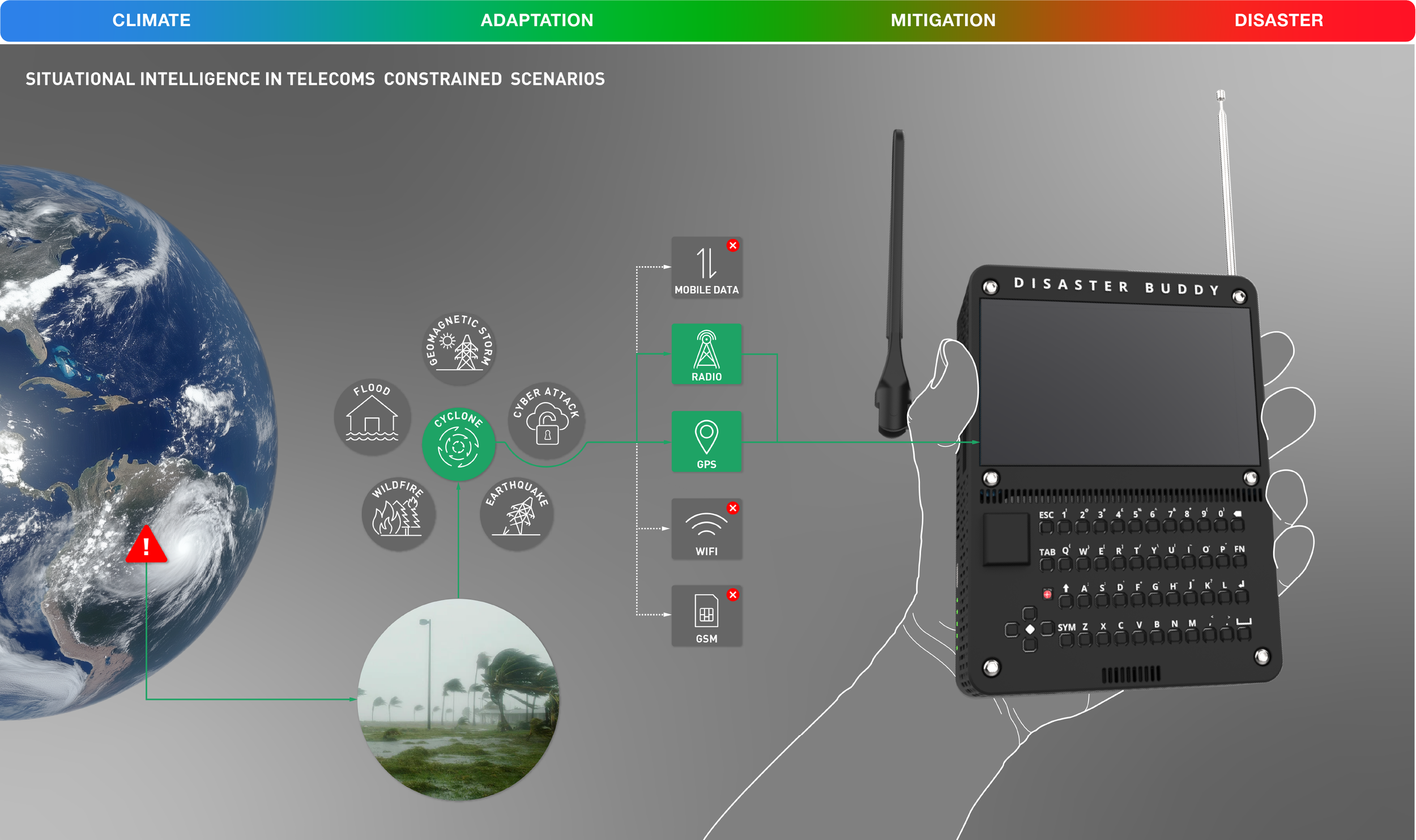
ECHO & Disaster Buddy (Agentic Crisis Command): Built in response to European flash floods that escalated from normal to catastrophic in under 60 minutes, ECHO fuses satellites, foundation models, and digital twins to compress rescue latency to seconds—and pairs with Disaster Buddy, a low-power handheld AI assistant that operates 100% offline when storms wipe out cell towers.
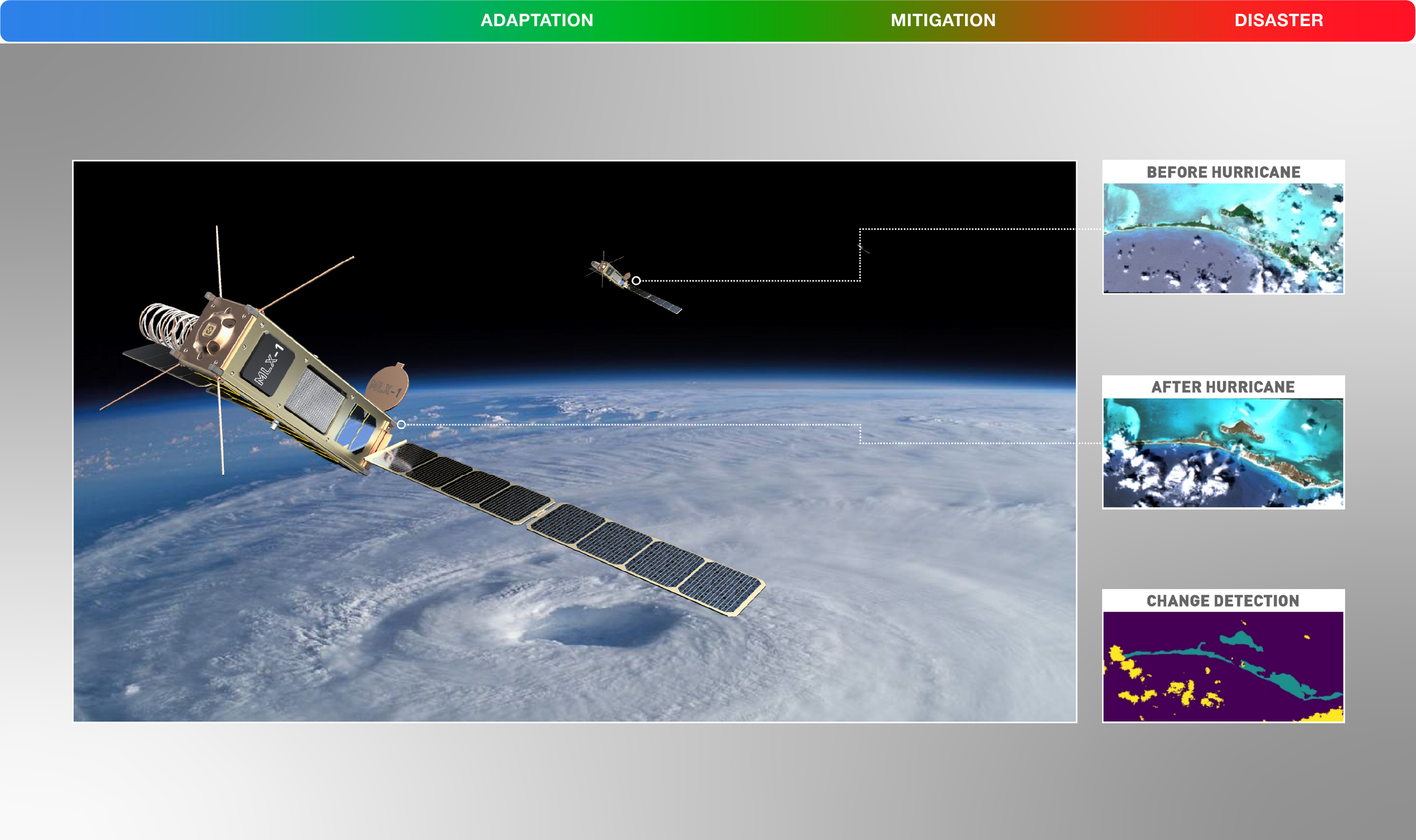
RaVAEn (On-Board CubeSat Change Detection): Published in Nature Scientific Reports, RaVAEn detects extreme disaster changes (hurricanes, fires, floods, landslides) unsupervised in orbit while requiring 60x less on-board memory than classical baselines—flagging coastal damage before raw images even downlink to Earth.
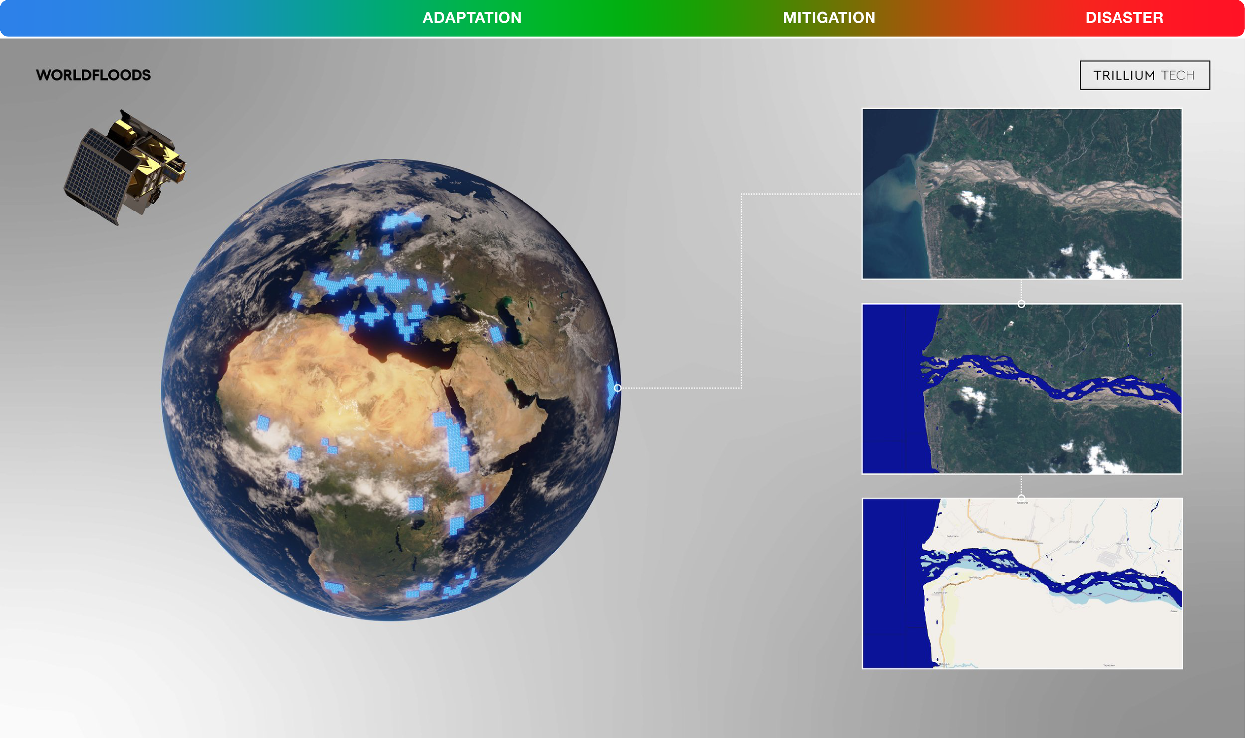
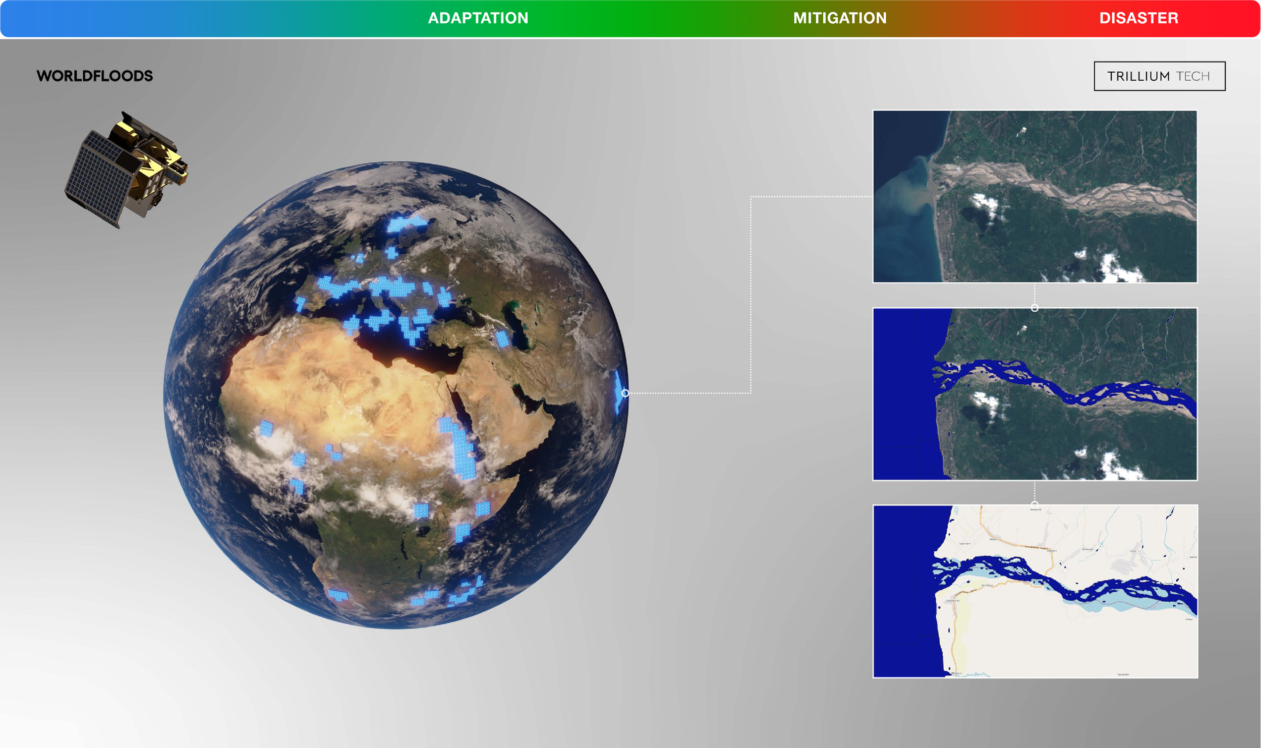
WorldFloods (Global Flood Segmentation): Trained on 509 Sentinel-1/2 scenes across 119 verified flood events, WorldFloods became the first AI ever deployed in orbit to segment floodwaters from space.
ML4Floods / ML4CC (UK Space Agency Toolbox): The first end-to-end open-source machine learning toolbox for flood segmentation and uncertainty mapping, adopted by UNOSAT (United Nations Satellite Centre) to put point-and-click flood AI into the hands of disaster relief coordinators.
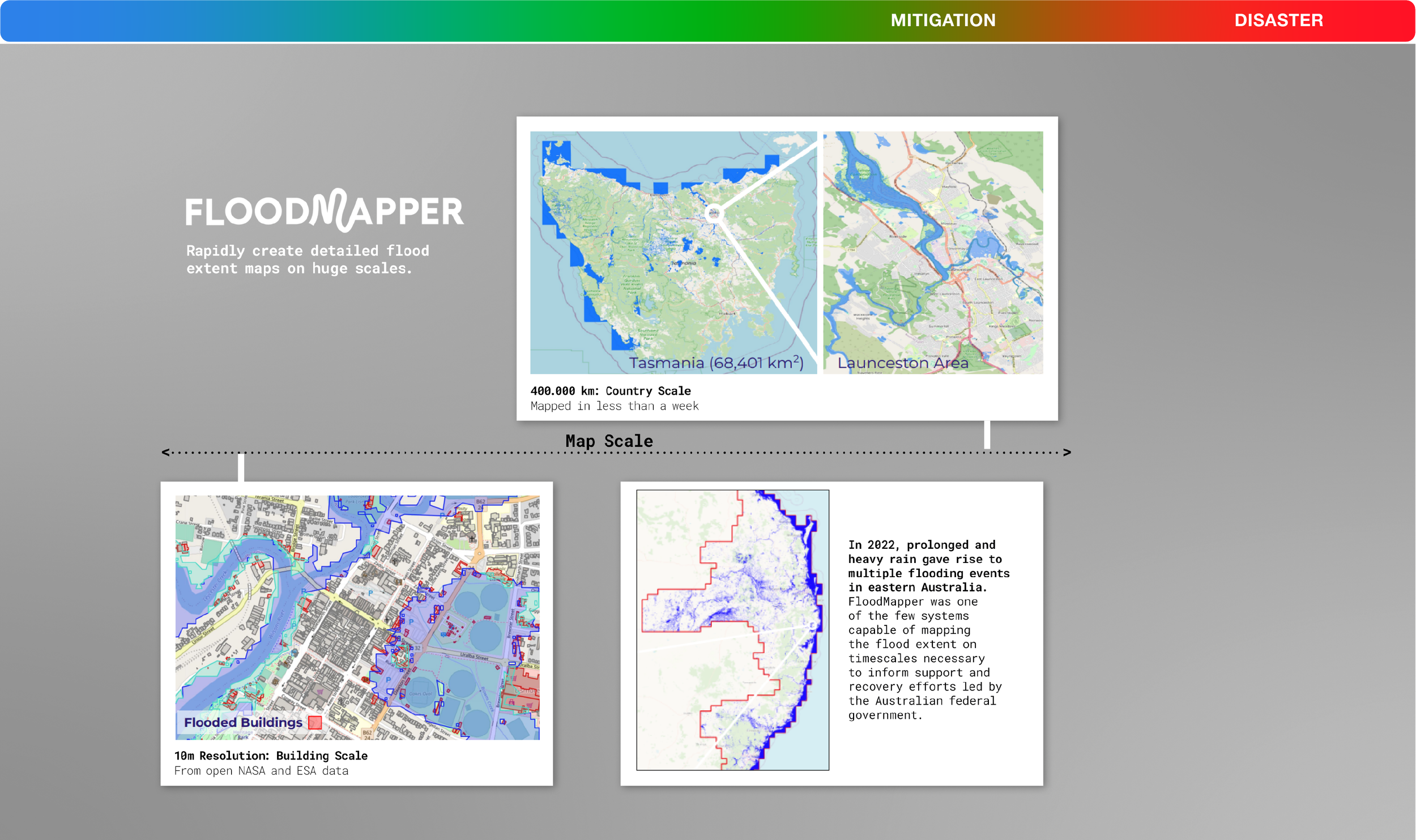
FloodMapper (Multi-Scale Rapid Mapping): Scales from 10-meter individual building footprints up to 400,000 km country-scale coverage, mapping 68,401 \text{km}^2 of Tasmania in less than a week and supporting federal emergency recovery during the 2022 eastern Australia floods.
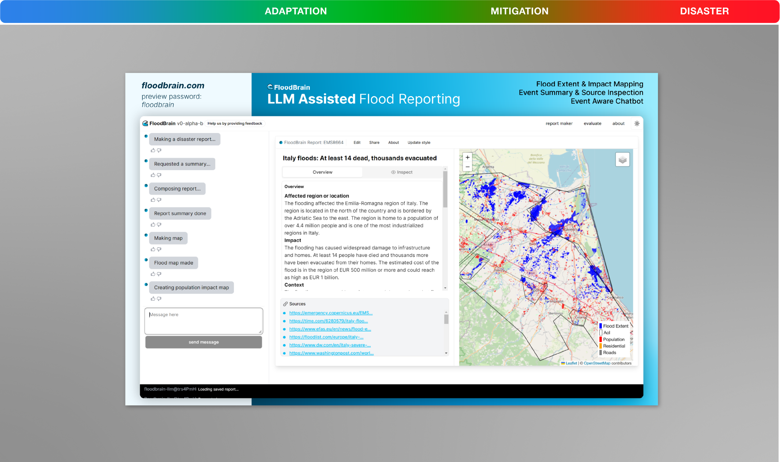
FloodBrain (floodbrain.com): Published at NeurIPS 2023, this LLM-assisted disaster reporting engine combines interactive street-level population impact maps with source-cited situation reports (such as tracking €500M–€1B in damages and 4.4M residents in the Emilia-Romagna floods).
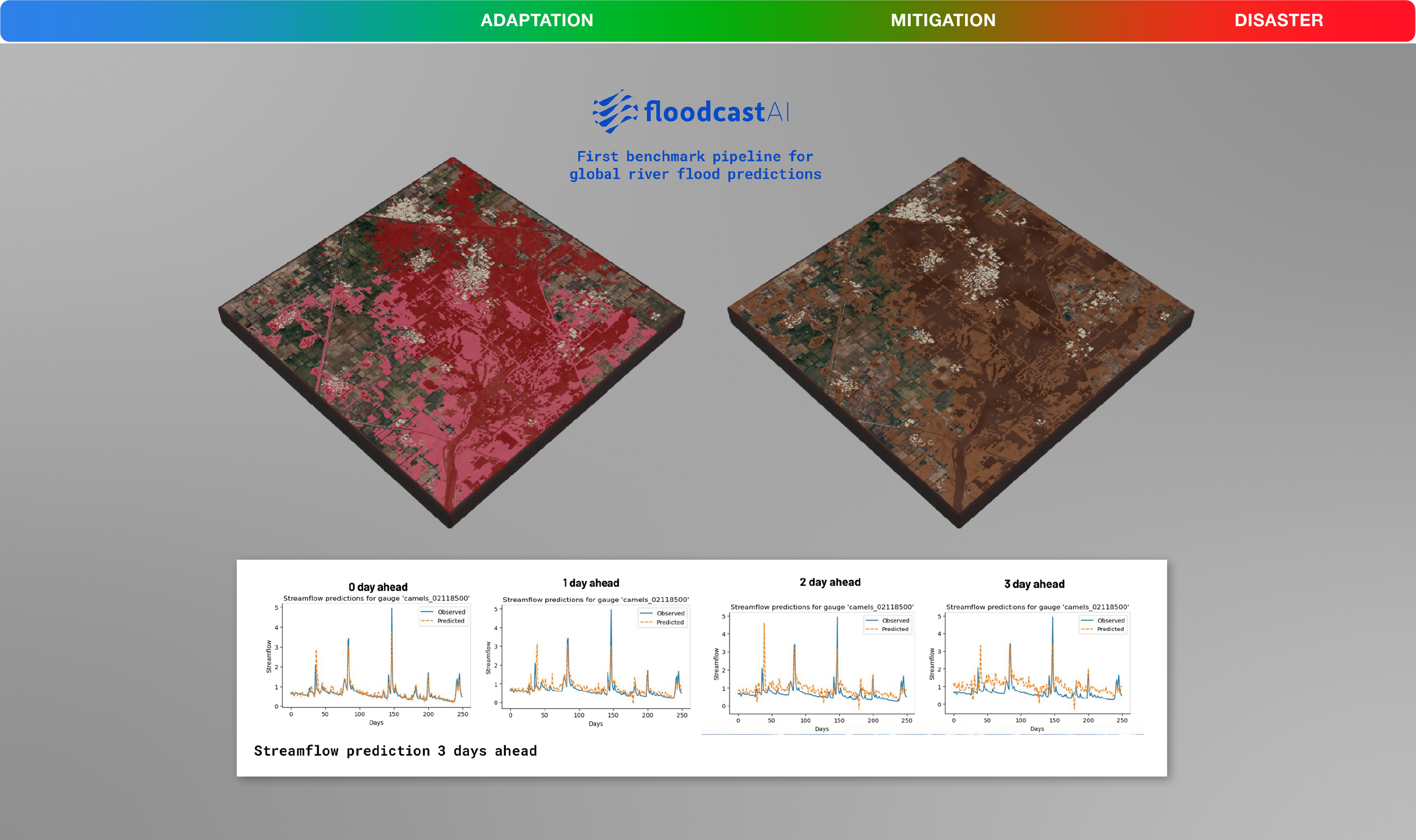
floodcastAI (Global River Flood Benchmark): Established the first global benchmark pipeline for river flood predictions, forecasting accurate river streamflow hydrograph peaks 0, 1, 2, and 3 days ahead paired with 3D inundation terrains.
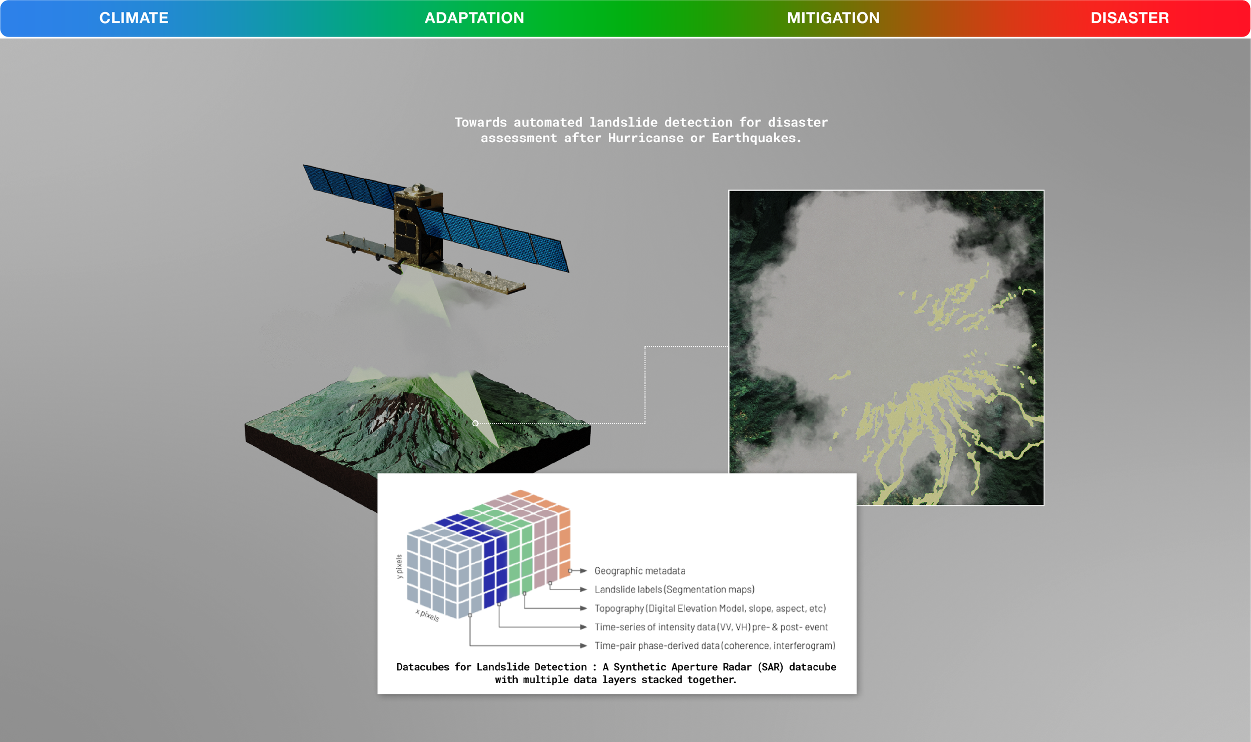
SAR Datacubes for Landslide Detection (DeepSlide): Stacks 5 radar and topographic data layers to see through post-hurricane and post-earthquake clouds, proving deep learning can rapidly detect deadly landslides using only a single post-event satellite pass instead of waiting months for multi-temporal series.
Tropical Cyclone Dynamics: Fuses 3 disparate satellite types (GOES-16 cloud tops, Metop-C microwave rain bands, and Sentinel-1B SAR surface winds) to close orbital swath gaps and predict deadly hurricane Rapid Intensification 12 hours in advance.
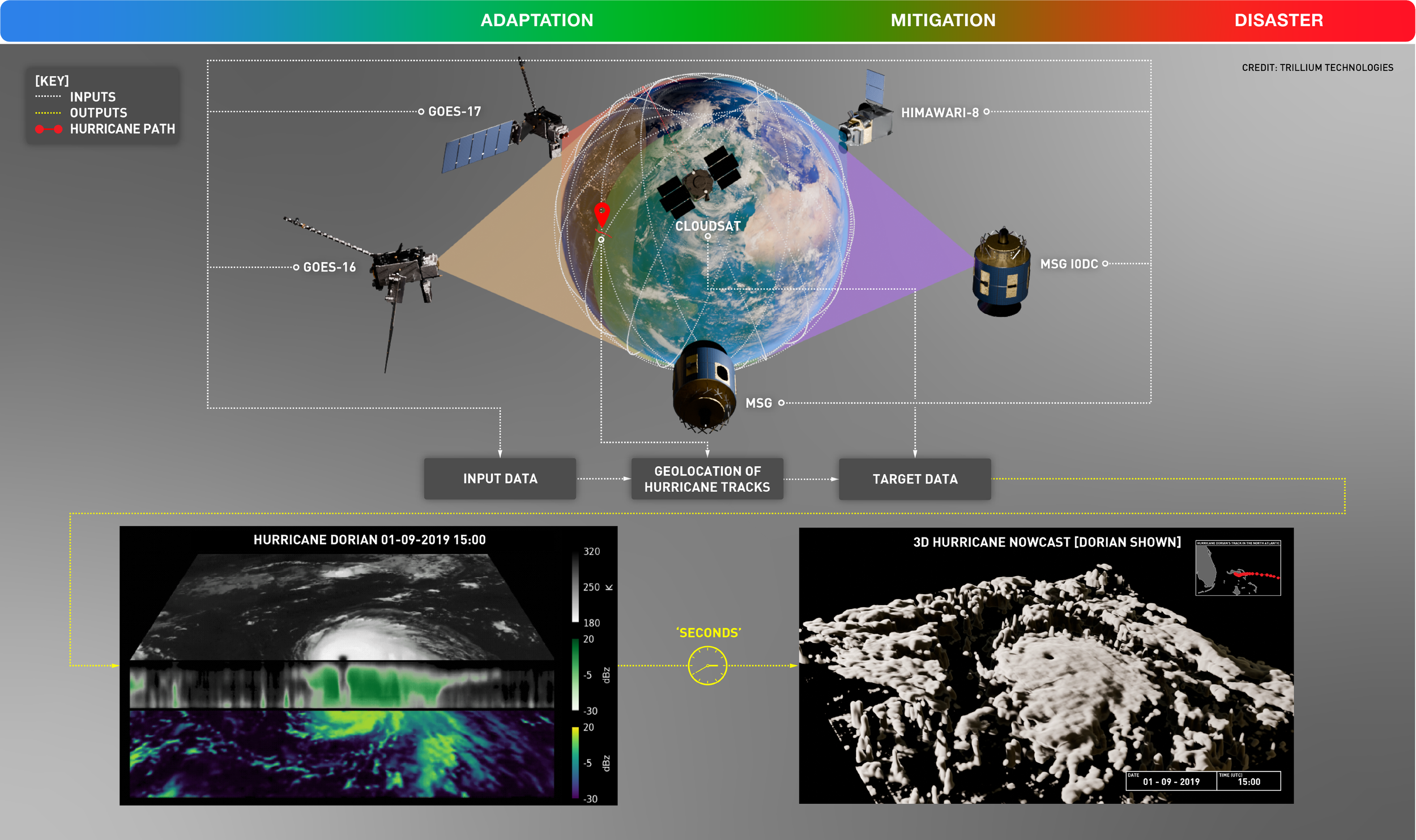
Multi-Sensor 3D Hurricane Nowcasting: Synthesizes data from 5 geostationary weather satellites plus CloudSat vertical radar profiles to reconstruct a full 3D volumetric hurricane structure (Hurricane Dorian) in just "seconds"—winning the Best ML Innovation Award at NeurIPS 2025.
GLM Instrument Upgrade (Lightning Pattern Detection): Uses Graph Autoencoders and the Gromov-Wasserstein distance metric to filter noisy Geostationary Lightning Mapper data by geometric shape rather than pixel location, spotting early electrical precursors to tornadoes and wildfires.
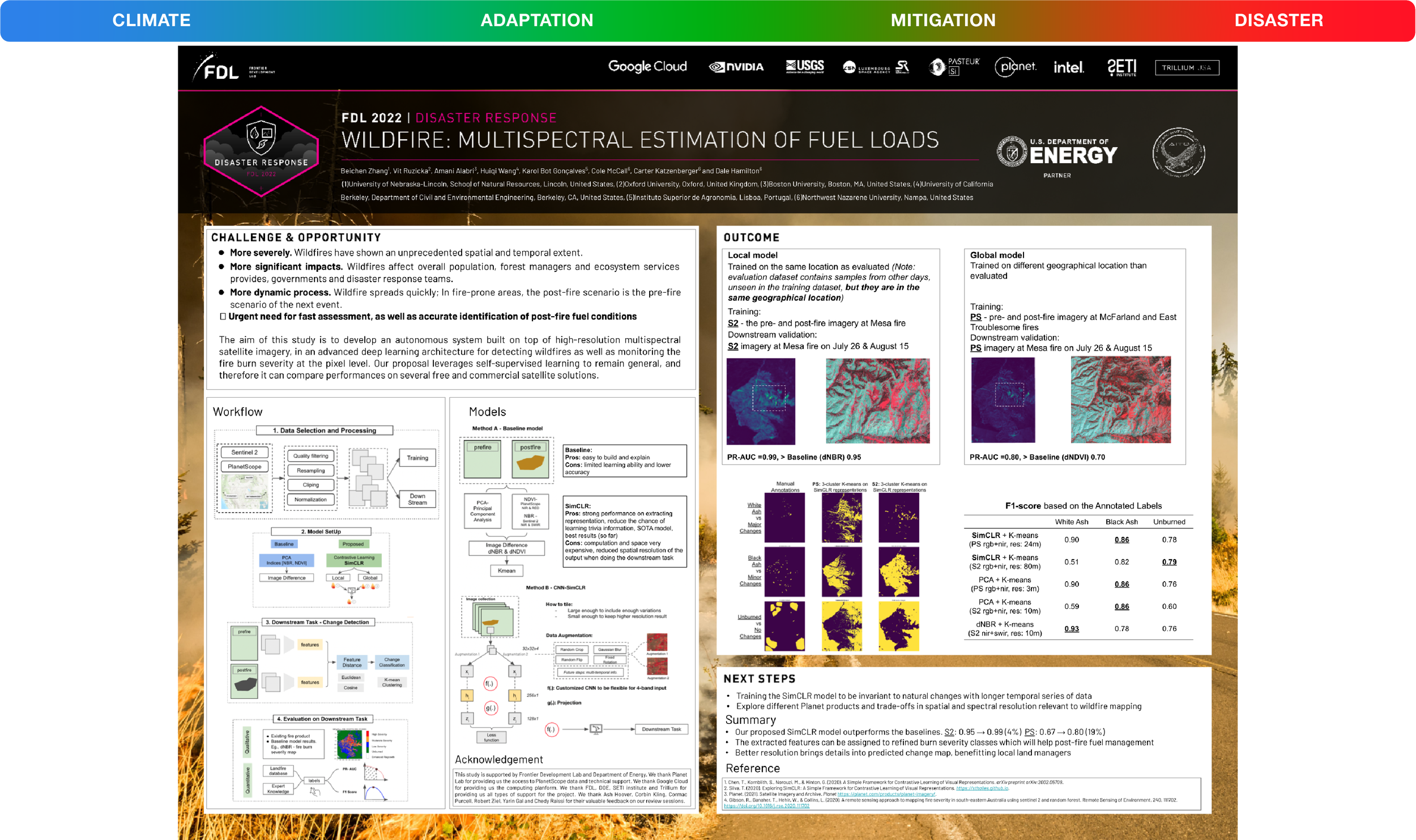
Wildfire: Multispectral Fuel Load Estimation: Uses self-supervised contrastive learning (SimCLR) across 4 spectral bands to boost post-fire burn severity and fuel-load mapping accuracy to 0.99 PR-AUC on local Sentinel-2 imagery and jump +19% (0.67 \rightarrow 0.80 PR-AUC) on unseen global wildfire locations.
Intelligent Systems for Bushfire Defense (Trillium Australia): Partnered with Australian researchers and state emergency services after the Black Summer megafires to build automated bushfire burn-scar recovery and real-time fire-spread prediction models from multi-sensor satellite constellations.
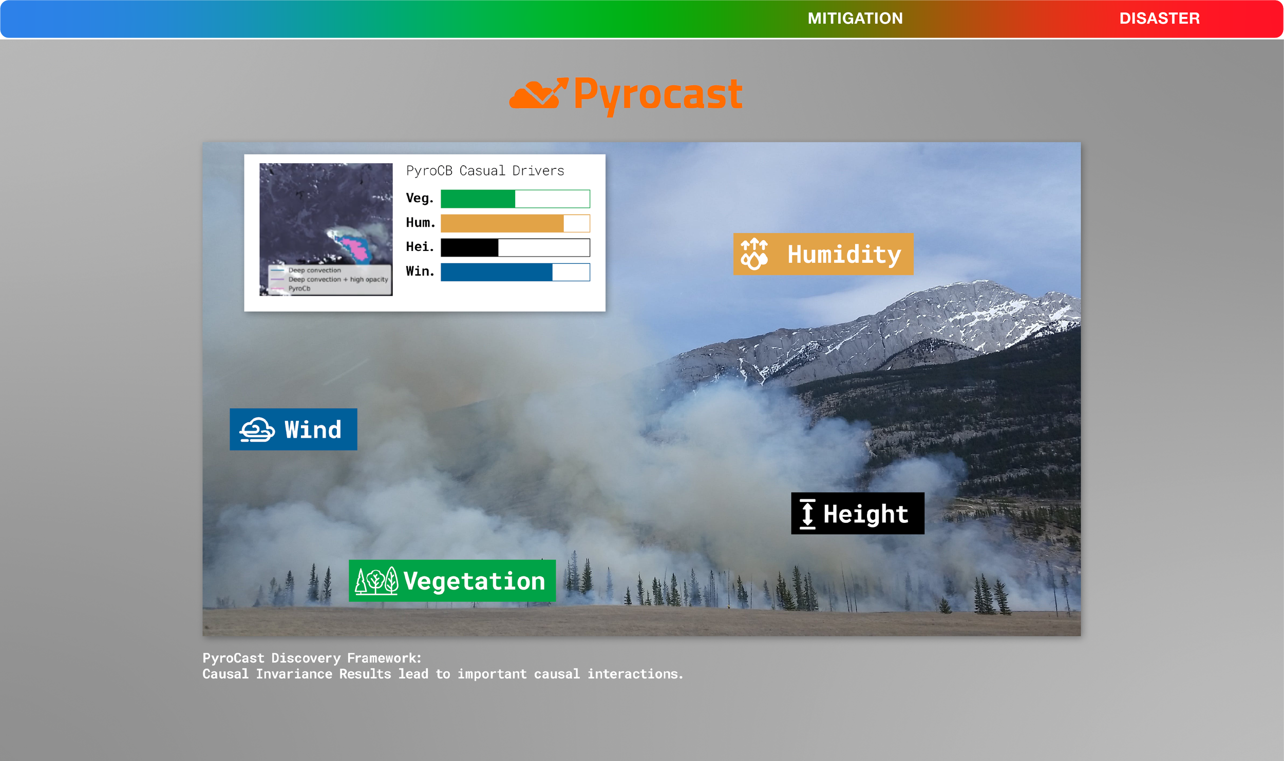
Pyrocast (Next-Day Wildfire Perimeter Forecasting): Combined geostationary satellite thermal hotspots with meteorological wind and fuel moisture grids to predict 24-hour wildfire perimeter expansion for incident commanders on the ground.
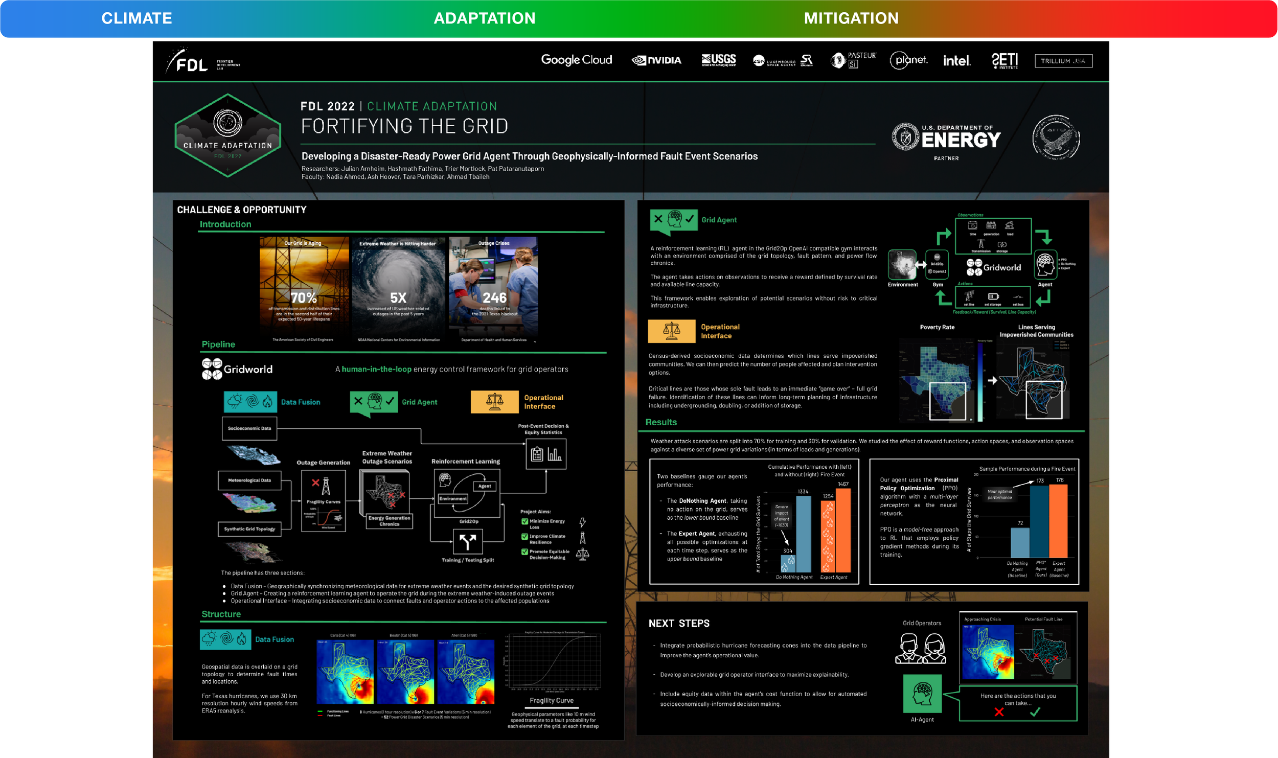
Fortifying the Grid (Gridworld): Tackles an aging US power grid using a Proximal Policy Optimization (PPO) Reinforcement Learning agent that achieves near-optimal survival during hurricanes (173 steps vs. 176 human-expert upper bound, compared to 72 without AI) while explicitly weighting census poverty data so low-income neighborhoods aren't left in the dark.
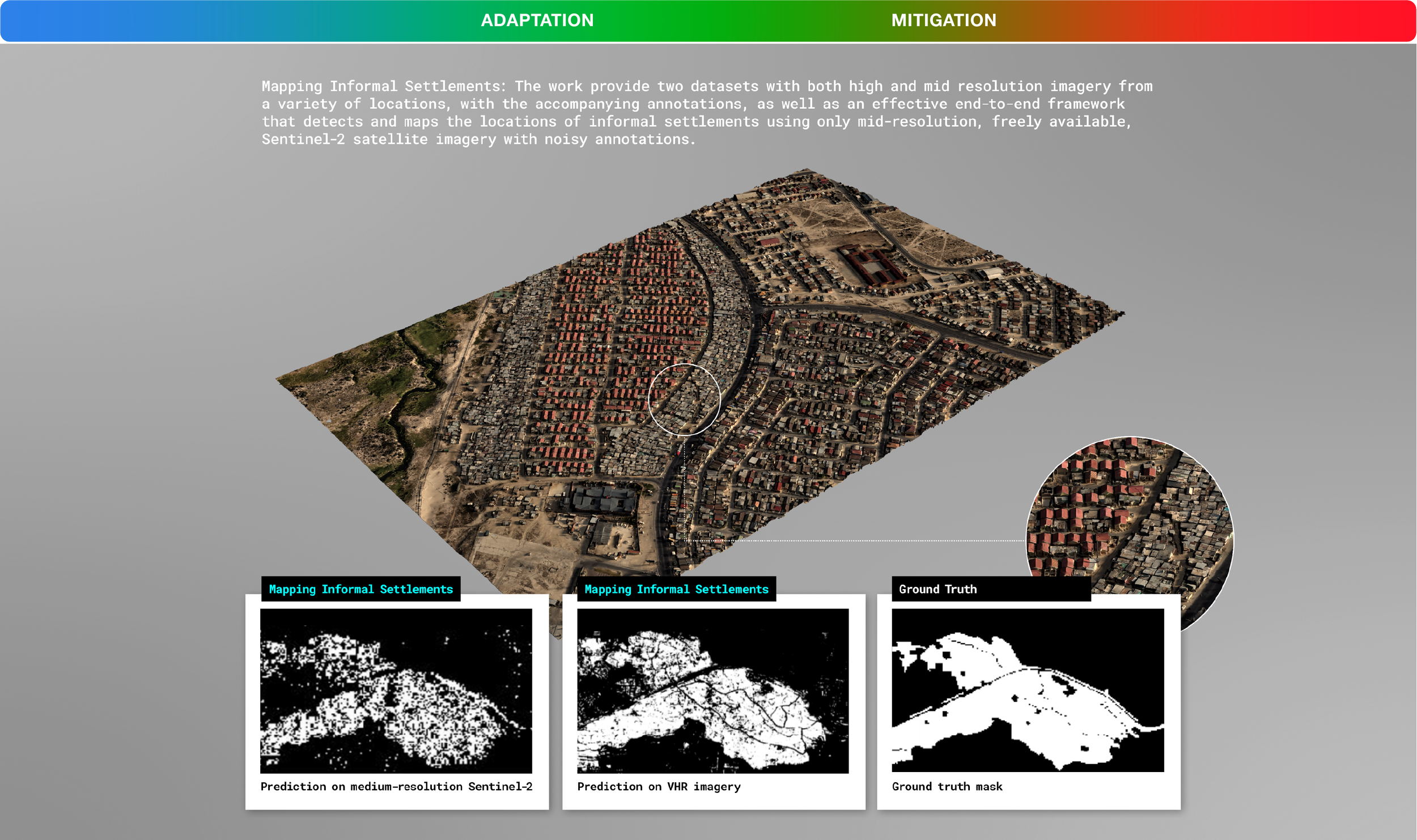
Mapping Informal Settlements: Proved that AI trained on high-resolution imagery can accurately map rapidly growing informal settlements using only freely available, 10m mid-resolution Sentinel-2 imagery—making unmapped communities visible to humanitarian aid.
Urban Rad Hunter (Radbot): Transforms raw gamma-ray spectra into multi-channel FFT images to detect 5 classes of shielded urban radioactive threats (\text{HEU, WGPu, }^{131}\text{I, }^{60}\text{Co, }^{99\text{m}}\text{Tc}) with ~87% accuracy in under 1 second on a single CPU.
USGS National Drought & Water Quality Forecasting: Partnered with the U.S. Geological Survey across multi-year sprints to build graph neural networks that forecast stream temperature, dissolved oxygen, and hydrological drought across thousands of river segments nationwide.
Desert Locust Swarm Prediction (FDL Europe / ESA): Fused satellite soil moisture, desert greenness (NDVI), and wind trajectory data to forecast locust breeding grounds days in advance, helping protect East African food security before swarms take flight.
Space Weather & Geomagnetic Grid Protection (Kp Index & 4 Solar FM): Built the first Foundation Model for the Sun and deep learning geomagnetic forecasters that predict solar storms before they induce currents that fry terrestrial power grids and climate satellites.


Act IV: Countering Stage IV (Terminal Cascade) Epistemic Humility & Off-Grid Regenerative Hardware
Stage IV of the \varphi Index describes the collapse of centralized supply chains, the loss of coral reefs and forests, and forced reliance on localized survival. To prevent—and reverse—that trajectory, these final 9 breakthroughs pair foundation models humble enough to know their own limits with autonomous, off-grid, solar-powered hardware that prints coral reefs, drops forest incubators from drones, and turns estuary seaweed into local clean fuel.foundation models humble enough to know their own limitsautonomous, off-grid, solar-powered hardware
SHRUG-FM (Uncertainty-Aware Foundation Models): Winner of the Best Paper Award at EarthVision 2026, SHRUG-FM teaches geospatial foundation models to say "I don't know" (#MakeFMsayIDK)#MakeFMsayIDK by outputting real-time dual reliability gauges (e.g., flagging 0.14 Model Reliability and 0.27 Data Reliabilitywarnings) so emergency teams never act on an AI hallucination in extreme environments.
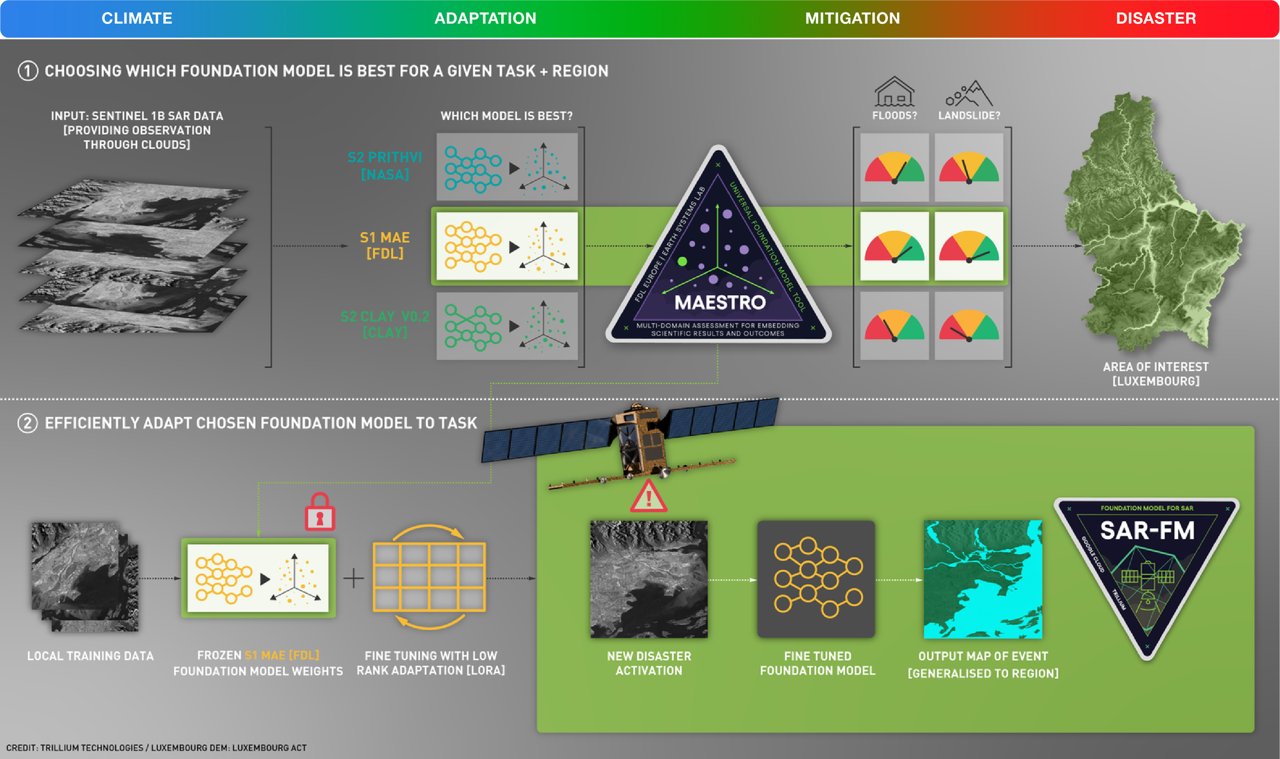
MAESTRO & SAR-FM (Universal Model Selection & LoRA): Evaluates competing foundation models (NASA Prithvi, FDL MAE, Clay v0.2) across tasks and regions, then uses Low-Rank Adaptation (LoRA) on frozen weights to rapidly fine-tune a cloud-penetrating radar model (SAR-FM) for local flood and landslide response.
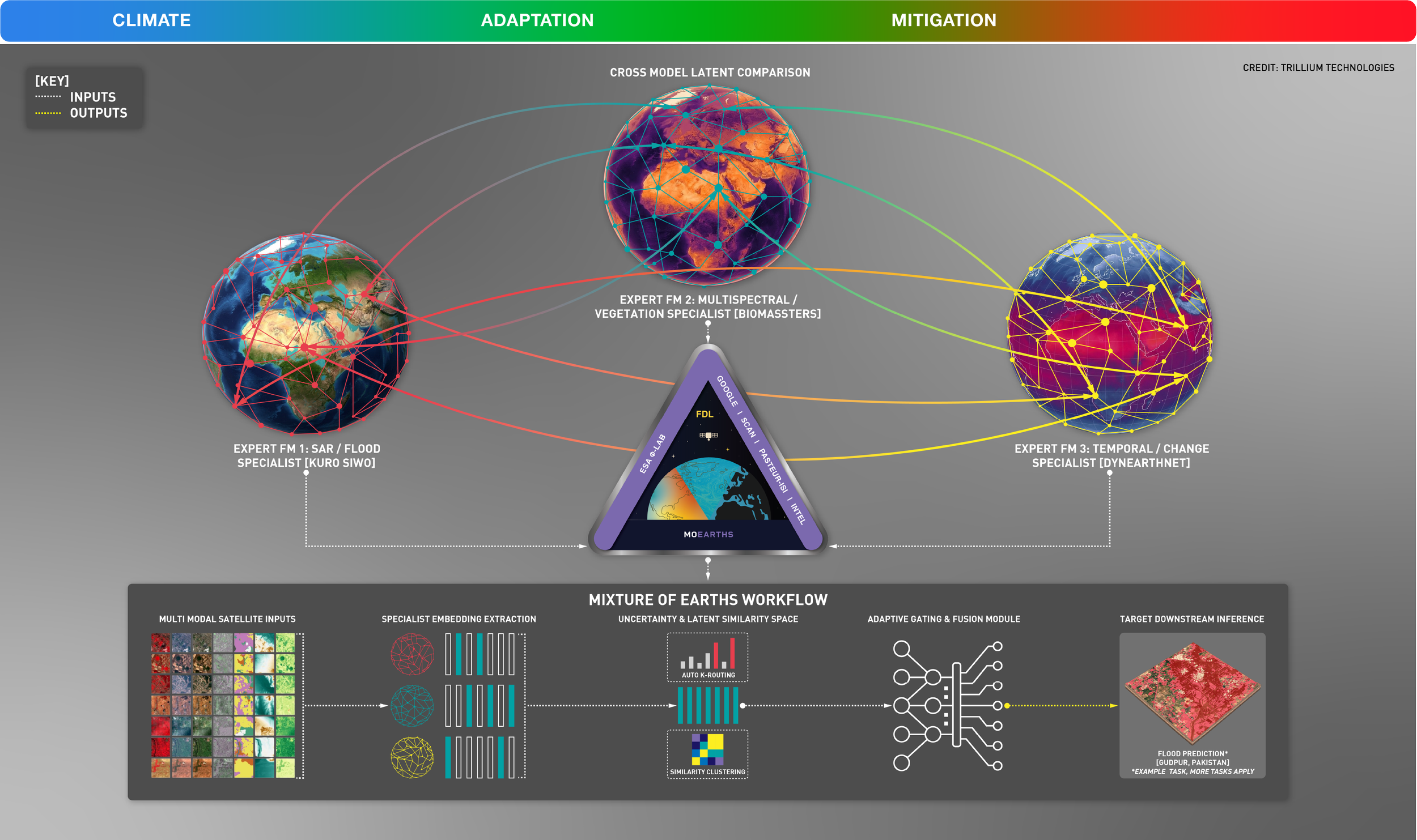
MOEarths (Mixture of Earths): Orchestrates 3 specialist Earth foundation models simultaneously (SAR/Flood Kuro Siwo, Multispectral/Vegetation BioMassters, and Temporal/Change DynEarthNet) using Auto K-Routing in latent space to dynamically fuse the best intelligence for regional crises like the Pakistan floods.
ExEBench (Extreme Environment Benchmark): Built a harmonized multi-spectral benchmark across 250,000 global SSL4EO locations and 804 Landsat/Sentinel-2 burn-scar scenes (trained on 800GB+ RAM DGX clusters) to stress-test whether foundation models survive out-of-distribution climate extremes.
TrustOps & AI Scientist: Developed an agentic "AI Scientist" and governance framework (TrustOps) that orchestrates foundation models alongside classical physics methods to test scientific hypotheses as a verifiable, auditable colleague.
FDL Foundations for Africa: Launched an international initiative with NASA and ESA to adapt open geospatial foundation models directly to African climate resilience, agriculture, and disaster use-cases.
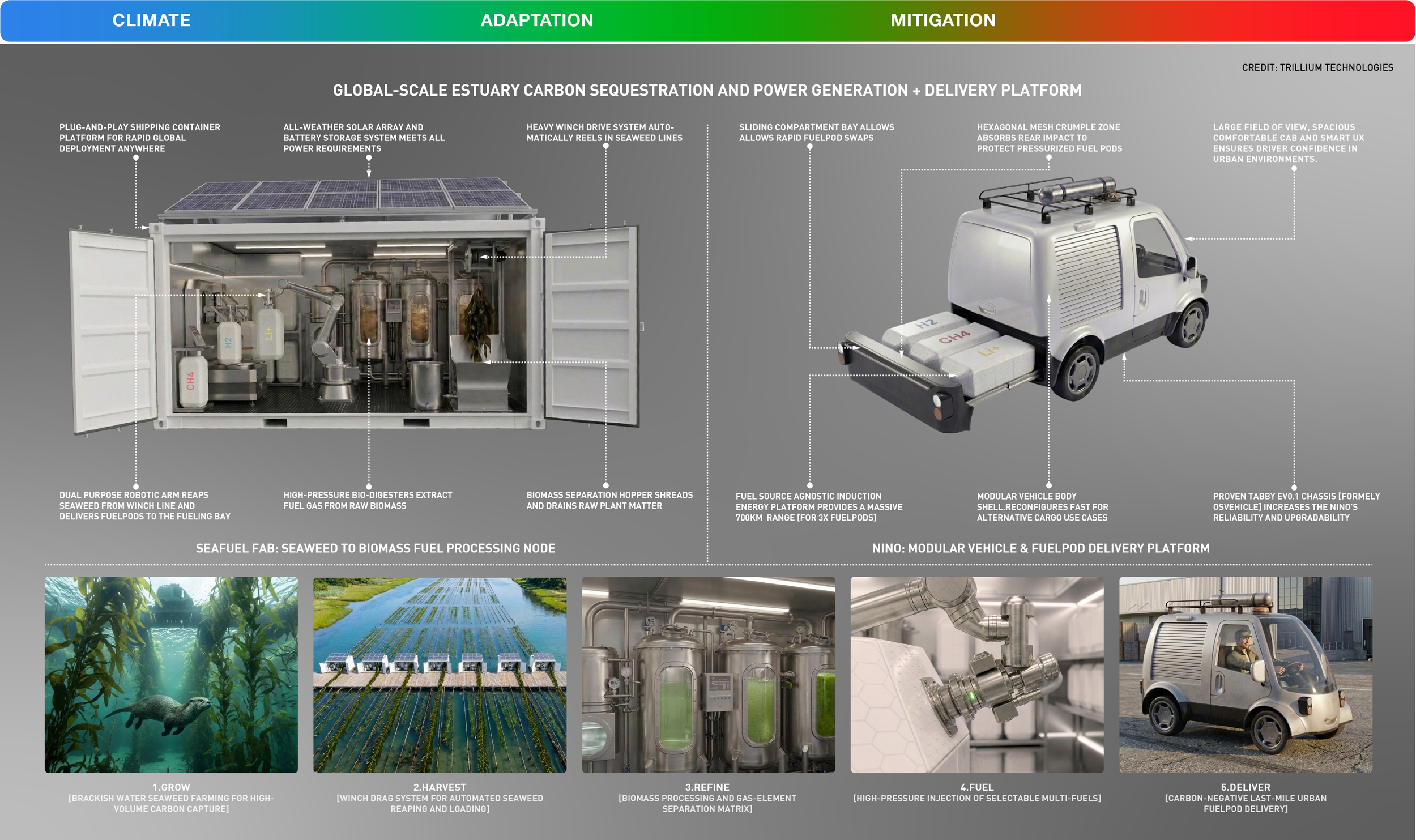
Seafuel Fab & NINO (Estuary Carbon & Clean Mobility): Combines a 100% solar-powered, off-grid shipping container bio-refinery that harvests brackish-water seaweed into multi-fuel pods (\text{H}_2, \text{CH}_4, \text{Li}^+) with NINO, a modular urban delivery van that swaps 3 fuelpods in seconds for a 700 km carbon-negative range.
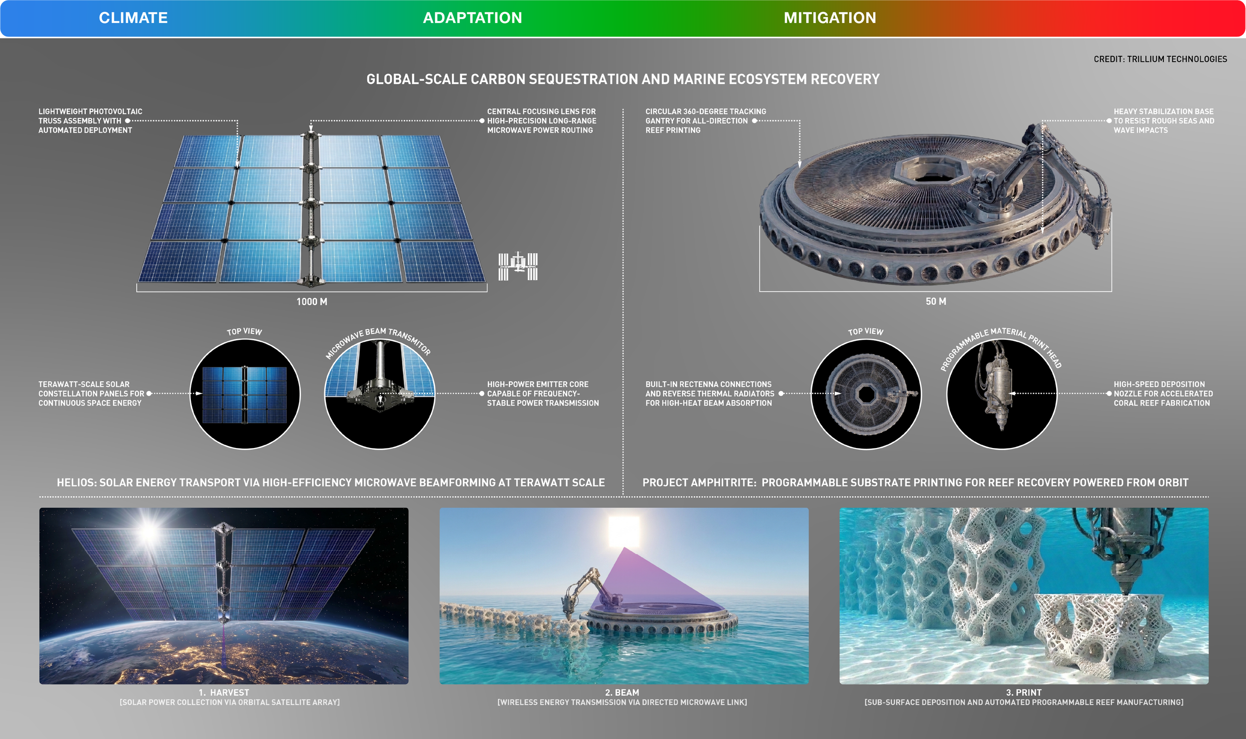
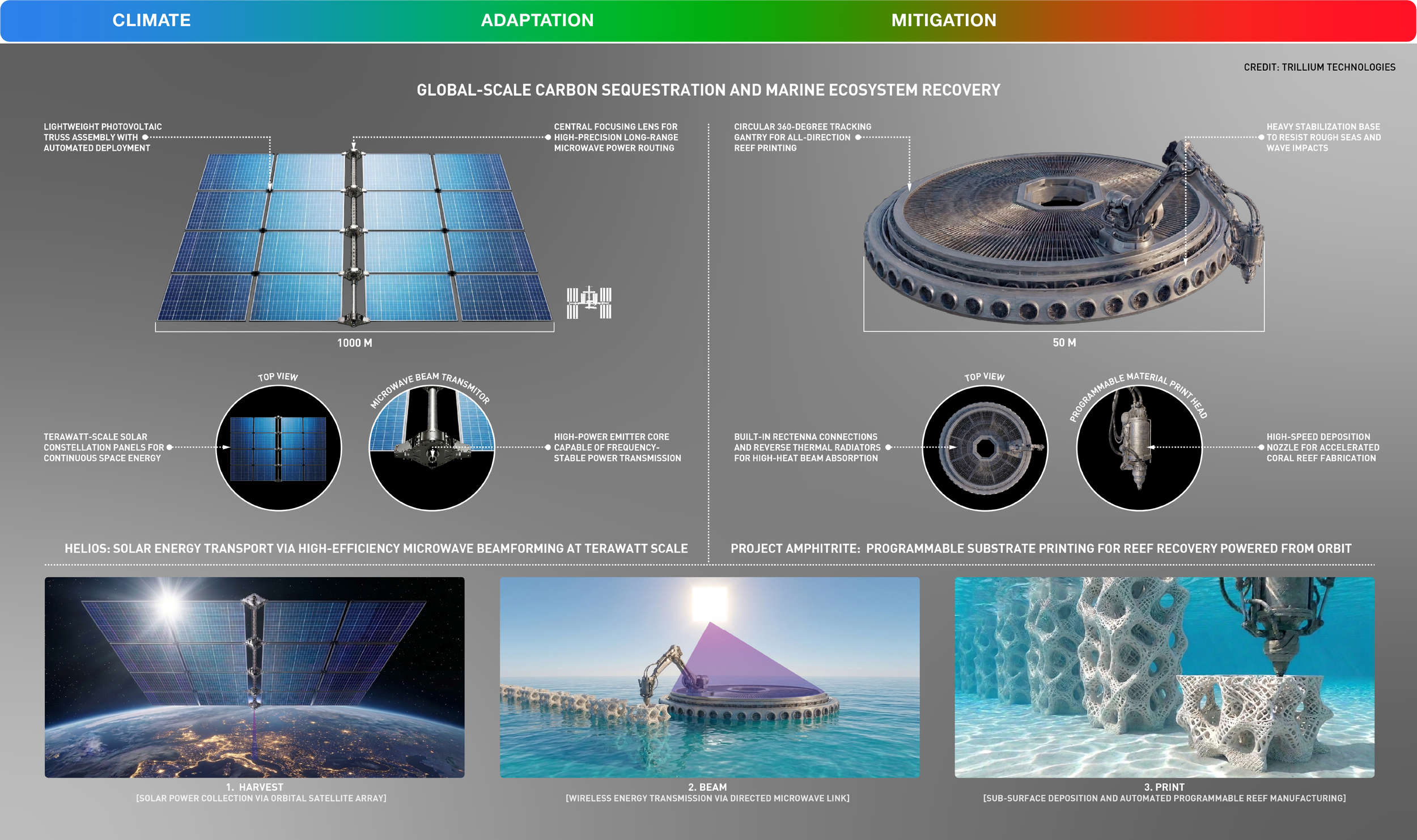
Helios & Project Amphitrite (Orbit-to-Ocean Reef Printing): Pairs a 1,000-meter orbital solar array beaming terawatt-scale microwave power from space with a 50-meter wave-stabilized ocean platform that 3D-prints calcium coral reef substrates across 360 degrees to restore marine biodiversity.
DropFab & Regenesis Egg (Autonomous Forest Recovery): Deploys an open-source, HEPA-filtered off-grid container lab (DropFab) to 4D-print biodegradable seed incubators that drop from drones, use a self-tapping spiral screw to survive high-velocity ground impact, and evolve through 6 biological stages from root shield to canopy wildlife nest.


The Fulcrum Is in Our Hands
Look back at the Planetary Habitability Index. The reason Stage II ("YOU ARE HERE") feels so overwhelming is that a tipping point is, by definition, a moment of maximum instability. When a system is poised on a knife-edge, fatalism is a self-fulfilling prophecy—because doing nothing lets gravity pull the system into Stage III and IV.
But a knife-edge works both ways.
When a system is balanced at a tipping point, the leverage of positive action is also at its absolute peak. When an orbital neural network shuts down a 27,000-tonne methane leak, when a tablet runs a 22-hour supercomputer carbon model in 120 seconds, when an AI model has the scientific integrity to say "I don't know", and when an off-grid container starts printing forests and clean fuel from sunlight and seaweed, we are placing massive weight on the other side of the scale.
Doomscrolling is passive. Engineering is active. We are at the tipping point—stop scrolling, and help us tip it.